Thursday, August 1, 2013

Summer Photos: AK


It's been a busy summer - record warm temperatures (70's) and an incredible streak of sunny days.  Winter was long but once the sun decided to show up the snow went fast.  Warm days and short nights conspired to quickly dissipate the snow.  Corn skiing was in short supply this year we went from mid-winter conditions to summer snow in about 10 days in late May.  But, as always, we've made the best of a great situation!

Here are some of my favorite photos from the 1st half of the summer.

Enjoy!

  - U.K.


Foraker/Hunter/Denali and the Knik Arm (2AM)
Above Anchorage- June 18

The Noodler and N$ on an Underused Trail
Falls Creek - June 6

N$ High in Falls Creek
June 6

This Narrow Gully Connected to the Ridge
Mountain Harp - June 8

Melting Tarn
Penguin Ridge - June 23

Schuss-Bow
Tincan - July 7

Todd's from the Seward Highway
July 7

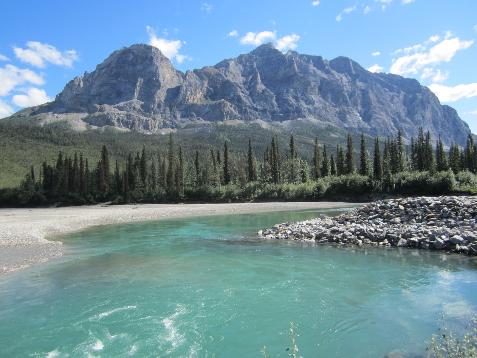
Mountain Sukakpak and the Koyukuk River
Brooks Range - July 11

The Noodler and the Fog
East Twin Peak - July 14

Dip Netting
Kenai River- July 19


Filleting on the Beach
Kenai River - July 20

Friday, May 31, 2013

Skiing the Boretide

Tide book - check. Bear mace - check. Ski gear - check.
 
Owley and I were ready for a late May ski near Penguin Ridge. We chose this spot for its proximity to the Turnagain Arm as we hoped to watch the bore tide from an aerie 3,000' above the cold, grey North Pacific.
 
Bore tides are a rare phenomena that only occur two places in the United States and then only with specific tides. Bore tides only occur only in shallow inlets or rivers with narrow inlets to the ocean. As the narrow inlet is still draining with the outgoing tide, the flood tide is already en route. The incoming tide travels against the current of the inlet. Moon versus gravity plus hydraulics and harmonics create a single wave that can travel for miles. 
 
I've witnessed the Bore from sea-level at one of the many pullouts along the Seward Highway. Being so close to the wave gives you a great feel for the power of the bore: loud and powerful, sometimes reaching a height of 6 feet, but the experience is short-lived. I hoped that from high above, we could witness the full scope of the Bore Tide as it traveled the entire length of the Turnagain Arm. 
 
Owley Climbing
Our extendo Winter ended abruptly and transformed into what the local Fox affiliated has dubbed: The Great Alaska Heat Wave of 2013. Local news tends to the overly dramatic - 3 days in the 70s is not deserving of such a grandiose title. But considering we were shoveling on May 19th and mowing the lawn on the 27th, the change has been dramatic.

This drastic change has put an end to winter snow conditions. Summer skiing is here which means alder smashing, sweat in the eyes, and skis on the back. The first 600' of hiking had mud, ice, slush, and alders, and the occasional patch of dry ground, but we were soon skinning. The trusty tide book told us where and when to expect the Bore Tide and we were right on schedule. 

Our first views of the Turnagain Arm came at 3,000' as we gained a sub-ridge. The entire Arm was laid before us: Anchorage all the way to Portage. We saw a slow moving serpentine wave out near the mouth of the Turnagain Arm. It made a huge loop and over the course of 15 minutes the loop collapsed on itself.  A new wave took over and center-punched the Arm.

The Bore Tide Center of Photo
The Bore was moving imperceptibly. From the road, the wave is a noisy, violent, dramatic act - churning and foaming ripping through the silty water. From up high, the bore is a peaceful wave meandering slowly and silently.

The day was warm and there were no winds. We sat on a dry patch of tundra watching the wave and a young eagle riding thermals. Sweat soaked gear dried and energy bars that have made a dozen trips succumbed to the extended rest demanded by the scenery.

Juvenile Bald Eagle Soaring


Secondary Waves (called "Whelps") Fan Out
Most witness the Bore Tide from pullouts along the Seward Highway. From these vantage points, you can get a great sense of the fury and awesome power of the wave. But from high above, the beauty and scope of the wave becomes obvious. Instead of a 5 minute noisy display of raw power, we were treated to a full hour of grace and fluidity in the silence of the mountains. Eventually, the Bore Tide weakened and slowly faded in a deep channel on the far side of the Arm.

 
Owley Laying Down Some Trenches
Our timing to watch the Bore Tide was impeccable, but the snow let us know we had missed the good skiing by several hours. The snow - well past corn - was a sloppy, manky mess. We left deep trenches as we descended. My wide open turns failed to produce the speed desired. It was work, but good work. After 2,400' of continuous schussing, it was time to accept that skiing to the road is no longer an option. The downhill hike to the trail was easy and relaxing. The bend of alders and gravity were working with us and we were soon back at the lot.

The June 24th and July 23rd bore tides are expected to be the biggest of the year. The hiking to skiing ratio will be much worse, but I expect to be up high watching the wave and making turns.

Click here for times & dates for 2013 Bore Tides 

 - U.K.

Tuesday, May 28, 2013

May Powder in Alaska


Well, maybe not quite endless, but May sure was good.  The storms kept coming and the temps stayed low.  We didn't get onto anything too rowdy, but a good time was had each time out in this late season powder. Enjoy these May Eagle River shots:

The Noodler on the Ship Creek Side: May 4

The Noodler on the South Fork Side: May 18
Big Group Heading up from Hunter Pass: May 19

Him on the Ship Creek Side: May 19
Some of Our Work on the Ship Creek Side: May 19

Turns on the South Fork Side: May 21

Storm Skiing on the South Fork Side: May 18


 - U.K.

Thursday, May 2, 2013

Electric Mountain: April 12, 2013

Social media told me that the Headwall would open for the first time of the season. Work just didn't seem that important, so I grabbed a voucher and headed South.  I had planned on heading North and skiing solo, but recent incidents in Alaska and Utah had me on edge. Some steep resort skiing would be perfect.

Eight years working at a ski hill has prepared me for the powder panic.  I know the drill: line up early, size up your competition, go like hell to your chosen line.  It was a cold, brilliant morning.  It takes 2 lift rides to access the Headwall.  On lift ride #2, our quartet of strangers blocked the sun from our eyes, trying to pick our lines.  From Chair 6, there is a long traverse to a steep booter.  The traverse is flat: no gravity assist, no sidestepping - just double pole planting and shuffling.

The Booter
Patrol got a early morning bump to the ridge to stage rescue supplies and set up some shelter, but by the time public arrived there were 5 or so ascending the booter.  At the transition area, a patroller was checking beacons.  I was second and the first wave was moving fast. About 3/4 of the way, the 1st pre-public skier dropped in.  It was going to be sweet.  Stoke was rising.  Most of the Headwall was bombed out with debris crossing the traverse except for one spot that I am sure we were all eyeing.  It was just climbers' left of the booter.  

The 1st paying customer gained the ridge and 30 seconds later a patroller dropped into that powder we all wanted.  It looked awesome!  Snow was hitting him solid in the thigh and was billowing across his chest. Then after a deep turn 30' to my left, the slope shattered about 40' above him.  

Fuck.

It broke about 2' deep and he was caught and accelerating rapidly. He went over a steep roll over and was gone into the powder cloud.

"Avalanche!  Avalanche!"

I ran the last 30 steps to the ridge to get my skis on and start a search.  There was a patroller stationed at the top of booter unaware what was unfolding below him.  After a few tense minutes the radio let us know the victim was on top on no one else was caught in the slide. 
 
Fracture


The slide ran the full length of the booter and then some.  Revisiting the photo above, you can clearly see the fracture line and the debris going past the traverse into the booter.  It was amazing no one was caught in the traverse / booter transition area.  For the rest of the day I never saw less than 5 people in this area where a slide ripped through just hours before. 

After about a 45 minute hold on the ridge, we were given the green light.  The death in Utah the day before was fresh in my mind and my confidence in Alyeska was shaken.  I opted to ski a line that was completely bombed out. Still I was nervous and had another hiker get "eyes on" for the descent.

The snow was not that good (maybe an old melt/freeze layer) but the reverse camber skis make quick work and I was quickly down the steep pitch and onto familiar terrain. 

I managed 2 more Headwall laps that day.  It was getting tracked out, so with more data points I elected to ski some of the softer options.  The sun lit up the Headwall in the early afternoon, but the booter stayed in the shade.  It's a great hike with amazing views.  Unfortunately, this area is rarely open: just 1 day this season. 

When it opens again next year, I'll call in sick and make the drive again.  But if I'm in that first wave, this time I'll be with a trusted partner with the necessary rescue gear.

 - U.K.


Thursday, April 11, 2013

North Bowl: April 9, 2013

Snickers, the porcupine, did not see his shadow thereby dooming us to an early Spring. Well, that prickly bastard could not have been more wrong. Even the State of Alaska has recognized Winter's unusually aggressive push into Spring by extending the date for removing studded tires. 

The weather guessers predicted a huge Saturday though Tuesday snow event. The hype was on, but early storm totals fell short of predictions. A revised guess called for lower totals, but by Tuesday morning the truth exposed: Snickers and the weather guessers have similar accuracy. 

But a ray a hope: even though town was spared the fury of the storm, the mountains got pummeled - far exceeding even the most optimistic guesses.


Gee, I wonder where to go....
Field reports had confirmed the impressive totals and as the sun busted through the clouds on Tuesday afternoon, our destination was set. Hiland is a narrow winding road which makes getting stuck behind a school bus all that more frustrating. There are 2 buses: the 3:15 and the 3:45.  We've got the timing down so we usually hit the window between buses and drive like Bo or Luke Duke right to the trail head. Tuesday we were 5 minutes late and got caught behind the 3:45 bus at the bottom of the road. Shit! Lucky for us, the bus driver pulled over and waved us on. We cranked the Waylon Jennings and accelerated up the snow covered road.

Apparently, we weren't the only ones with powder fever and a rudimentary grasp of how to use the intertubes. Eight climbers were ascending towards the ridge and there were scores of tracks on the North facing slopes above us. Typically, this valley gets wind blasted during storms leaving many of the faces scoured down to tundra. This last storm didn't have the wind and the normally barren faces were tracked out with some deep looking turns. At least the uptrack was in.

The temperature in the parking lot was pleasant and the last of the clouds seemed to be breaking up. It looked like we were in for a nice evening of skiing so I left my long-johns and puffy in the Taco. After about 20 minutes clouds obscurred the sun and a chilly wind kicked up. I donned what little extra gear that was in my pack. Once on the ridge the wind really picked up making the single digit temperatures feel even colder. The wind was ripping, rapidly filling in the skin track and exposing wind board on some sections of the ridge. The blowing snow sand blasted my face and was rapidly sucking warmth from my body. For the second time this month, I coveted the Noodler's skirt. Getting desperate, I improvised a merkin with the bags for my goggles and climbing skins.  Ahh, much better!

It seems as though Snickers and I have similar weather guessing skills.

Fortunately, it was just a short squall. By the time we topped out on the 114th tallest peak in the Chugach State Park, visibility had improved and the winds had laid down.


Despite dozens of tracks visible from the trailhead, there were only 3 in North Bowl. The sun made a brief reemergence so the Noodler dropped in disappearing in a cloud of cold smoke. He quickly settled into his metronome style and attemped to make infinity turns. I wanted to ski more aggressive, but the angle was too low and the snow too deep.  I resigned myself to the tick-tick-tick of the metronome and enjoyed the ride.

A second lap was definitely in order. 

The Ridge Back to the Top
Along the way we met up with a couple of buddies and continued as a team of four. The squall from the first lap was long gone. Our persistance was rewarded with good visibility and light winds, but it still was cold.  We breifly considered another aspect, but elected to stack our tracks from earlier. On both runs, the first two turns were a bit funky, but it quickly changed to the deep fluff. 

The Noodler Stacking
Powder conservation techniques allowed everyone to get a fresh line for the entire descent. Smiles abound! Hoots and holler! It was my deepest Alaska day of the year. We wanted more but domestic obligations called us back to reality. 

Late spring dumps are precious because the promise of powder is fleeting. We may get another storm, we may not. This could well have been the last face shots of the season. I hope there's another monster low out there churning over the Pacific with Anchorage in her sites, but who knows?  Your guess is as good as mine.

 - U.K.

Friday, April 5, 2013

The Out of Service Couloir: April 2, 2012

The Out of Service Couloir goes by many different names mostly to keep people confused as to its true location. It's not really a secret, but invites to the uninitiated are rare. Fortunately, my friends are not very good at keeping secrets. This after work special is close to town and is the perfect option during breakup.

Breakup is the time between winter and tourist season.  Most people write it off, but breakup can deliver the best corn skiing of the year. Daytime highs climb into the 40s and nights drop into the 20s. It is generally the first consistent above freezing temperatures of the year, so the snow that has been piling up around town pools in the day and freezes at night. A slushy, dirty, splash fest in the afternoon, and gnarled frozen mess in the morning. The banks shrink and the standing water drains. First the highways dry out, then the main roads, the side streets, and last the alleys. The process takes about 2 weeks.

But back to the skiing...

This year the snowfall around Anchorage has been above average, but along the Seward Highway between Anchorage and Girdwood snow is well below average. There was never more than a 6" base on this stretch all winter. Every time I drove by the Out of Service, my neck craned trying to determine if there was enough snow to ski it. The top top half would be well filled in, but the bottom half kept me wondering.

It must have kept most of the skiing community wondering because info on the Out of Service was non-existent in our circle. So with a great deal of skepticism, the Noodler and I decided to give it a go.

The bottom 200 vert was mostly frozen creek ice with 2" of rapidly melting slush on top. Footing was tenuous at best and downright scary at worst. We scrambled through open water, ice, slush, rocks, and overgrowth until it began to open up.  At about 400' we were free from the encroaching vegetation and began to boot in earnest. 

The first section of the couloir is in the low 30s and the route is obvious, but that changes at the half way point. At about 1,750' it appears that you are almost at the top.  The shot gets wider and the angle eases.  This is where you take the improbable left. It doesn't look very promising, but if you climb a narrow steep spit of snow you are quickly rewarded with a skier's dream. 

You are suddenly in the high alpine with no vegetation and the Turnagain Arm is in your lap.  The angle increases into the high 30s with steep, jagged, grey-orange walls devoid of vegetation. No more shadows, no more gully, no more wondering why you brought a helmet and whippet.  Or in my case: wondering why you left your helmet and whippet at home.


Booting Above the Crux
The upper couloir has a few false forks, but with some good guessing and some experience, ski time comes at 3,400'. 

Getting Ready to Drop In
On the way up it was obvious that snow conditions were prime. The upper section is in fat and the breakup freeze thaw cycle had worked its magic. We had timed it perfectly!  There was 1-2" of cooked down powder on its way to corn on top of supportable. The turning was sublime. No one skied the upper half since the last snow over a week age, so it was super smooth and bright white. The ideal snow conditions allowed me to take in the incredible view of the cold grey Pacific that was rapidly rushing towards me.


The Noodler in the Upper Half

Every other time that I've skied the Out of Service Couloir, there has a lump in my throat above the crux. It is often too narrow to side slip. Other times it is 18" of rotten snow on straight rock. Sometimes both. But today there was no lump in the throat - we knew it was wide so we opted to ski it "family style."  

The bottom half has much less snow than 2011 and 2012. There were a few narrow spots, but the low angle allowed the stress-free descent to continue. Eventually the snow gave way to creek ice, water, rocks, and brush. Today the real crux was the last 300'. Our styles are firmly routed in East coast stubbornness which dictate you ski if there is white, no matter how ridiculous. We work our way lower and lower hanging onto to alders and side stepping over rocks and through the open creek. Eventually common sense trumped our heritage and the skis came off.  It wasn't over yet; there were still some harrowing steps, moments of self doubt, slips and saves, and the ever popular alder face whip.  But not even the stinging lashes could not wipe the smirks off our faces as we stumbled out of the brush and onto the rumble strip.

We were psyched to catch the Out of Service in first-rate conditions. Exhaustion and other commitments have prevented a return as of yet. Maybe we'll get it again, maybe not, but knowing that we nailed it will make that bitter pill called Summer easier to swallow.

 - U.K.

Mission Mts.- Mt St.Mary and Grey Wolf Peak

I have been planning a trip to ski in the Mission Mts. since I first laid my eyes on them three years ago while on a climbing trip throughout the Big Sky state. At that time I had never even heard of the Mission Mts., but when I got home I started researching their back country skiing potential. 

Missions Mts- looking North from East St.Mary
The Mission Mts. begin roughly 50 miles north of Missoula and run about 40 miles north towards the southern-most part of Flathead Lake. They rise at an average of 5,000 feet from the valley floor. Mt. McDonald is the highest peak in the range, at 9820 ft.

When I moved to Whitefish, MT at the beginning of this year I had a feeling that I would be putting in an effort to ski in this range. Coming back from Idaho three weeks ago we passed St. Ignatius- the gateway to the Missions- and thoughts began to pile up for when I could make this trip happen. Texts were sent to many Boyz with temptation to ski in the wild arena. The dilemma I am having now living so far north is having all of these epic mountains to climb, but no Boyz to ski with.

My dependable partner from the North, Dan Koestler, was down and we planned on being in the the Missions for Easter weekend. When he called just three days before we were supposed to go, telling me how he was put on the schedule unexpectedly, I texted again, to no avail. I began to make new plans for my weekend off work.

Then a miracle happened. My closest in proximity and most experienced Skier Boy Friend called and said he would go. YES! Thank You Jay Welz! It was a roller coaster of emotions leading up to getting to the trailhead and even after, but while we were in the mountains it felt like we were supposed to be there. The Missions approved of our dedication to exploration.
Happy Easter! Boyz on summit cone of East St. Mary
To enter the Missions from the west side you need a Tribal Boundaries Pass. A three day pass can be obtained in St. Ignatius at the Cenex Gas station for nine bucks. From there we drove up to St. Mary Lake.  On the western edge there is a pull out with a campfire ring and a cairn marking a trail. The road was mostly melted out, but I was happy to have Truckee.

The trail head
Our main objective in the Missions was to ski the West Couloir of Grey Wolf Peak. I had read many blogs from skiing this line and each one sounded like getting there would be a challenge greatly rewarded. After finding the trail we were surprised that it continued up to the snow line and a skinner was already in. We transferred to skis and followed the skinner to where the mountains revealed themselves. Gorgeous mountains shining bright in the sun and bluebird skies.
That approach wasn't so bad. I could have packed a few more brews

Welz below point 8700 ridge

Grey Wolf Peak and it coolers
At 4 pm, we reached the ridge at 8700 ft.  5 hours and 4800 feet of climbing later, we had a look at Grey Wolf Peak and the couloir we wanted to ski the next day. We ripped skins and skied a beautiful large bowl down 1700 feet to the base of the Grey Wolf where we would set up camp. The bowl is north facing so we carved some creamy archs and wiggles, pleased with the conditions and blown away with our position! After setting up camp we climbed back to the ridge for another descent of the bowl before the sun went down for the night. We cheers'd with a few brews and gulped some chai rum then slept under a Big sky of brilliant lights.
Amazing bivy spot
 The next morning we woke to another sunny day and after a quick hot meal we began skinning towards East St. Mary Peak. Because the snowpack was in a transitional stage and we had a good freeze over night we planned to ski the South face off East St. Mary then back to the Grey Wolf coolie which faces west.

Self portrait with the SOuth East Face of East St. Mary
After two and a half hours of following the Easter bunnies tracks we were standing on top of East St. Mary (9,400) and looking North to jaw dropping peaks and faces. The line has big exposure and its above a hundred foot cliff.  We dropped in before noon, a little bit on the cautious side because of the exposure involved. The corn was perfect off the top and getting towards the cliff it changes exposure a bit and was a bit firm. I did not care, what a line! So fun to be hopping down a big face like that feeling so small and vulnerable.
DAmn thats some creamy corn

Welz dropping off the summit cone of East St. Mary

From the bottom of the bowl we booted 1000 feet back up the ridge on the hard crusted west face. In an hours time we were back up to 8700 and looking over at our next objective, which seemed like we would be timing perfectly because the coolie was still in the shade. Shit! Someone was booting up our line. They sussed us while we were climbing or skiing East St. Mary. We were in awe and didn't know what to do.

We skied down back to camp and decided that the group was either going to wait for the apron to soften up, which would give us time to high five them at the top or they were just going to ski in in hard, scary conditions. So we went up and hoped they were Canadians so we could offer them a Kokanee if we got in their way.

Changing over from skinning to cramponing we waited below some rocks at the bottom of the chute. We began to see some snow pebbles come down through the chute and then some more and felt that the group ahead was descending. Alright, exactly what we were hoping for. We high-fived the gang from Missoula and began booting up the empty coolie above.

Do you think the Easter bunny hid any eggs up here?

Towards the top of the coolie. The terrain in the back ground is point 8700, where we made 3 laps in creamy powder conditions.
After a hour of stepping in and out of the old booter we were on top of the coolie. We enjoyed our position, ate some peeps and looked down the other side of our line to see another beautiful shaded cooler below. Maybe next time? We transitioned and started down this wonderful line. On the left side of the chute there was still dry powder so we hopped down that way and in the middle we got some corn.  By the time we hit the apron it had corned up also, perfect timing for the Boyz! Another amazing line.

Thanks for the Peeps. Now lets ski this line!

Welz dropping into the West Couloir of Grey Wolf PEak

Finding some soft snow in the shade

BAck out into the sun for corn.
PAcking up camp we knew that the hardest wasn't over. To get out we needed to climb back up to point 8700, then ski down the manky southwest ridge and try to find our trail back to the truck. This all was not too bad, mostly because we had spent the past 34 hours in place most skiers don't visit. Many people look up at the Mission mountains and stress how hard it would be to get on top of those peaks, let alone ski fantastic lines. As SKier Boyz, it is our nature to act on the urges of the the unknown terrain that stands above us.


SKiing out of the Missions to finish the mission

Sore feet. This is What we DO!

Getting back to the truck are feet were sore but our minds were at ease. Popping a victory brew we cheers'd to an excellent adventure, 13,000 feet of climbing, 2 memorable lines and a bivy worthy of the effort.

-Jakeums