Saturday, November 16, 2013

Bitterroot Mts.- Blodgett Canyon, Shoshone Spire 5.9

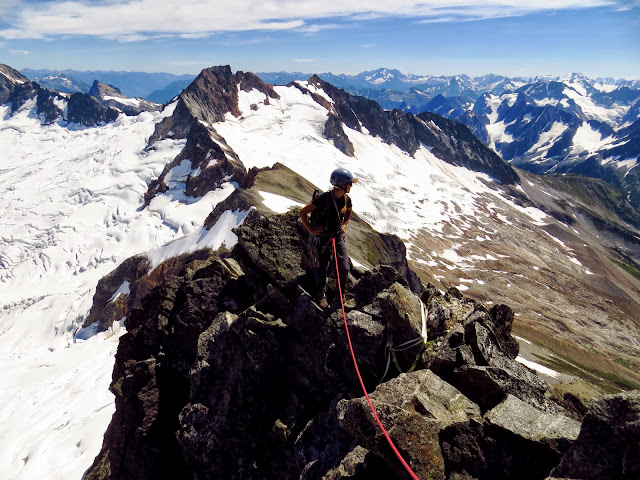
Standing on top of Shoshone Spire,
looking at the SW Arete of Nez Perce
During the soggy month of September in Whitefish, MT Gaelen and I were contemplating our relocation to the North. We hadn't climbed for two weeks and it was looking like the weather was going to skip the Fall season and go right into Winter. I love Winter, but not if I don't get to enjoy the best season for rock climbing, usually, first. Luckily for us Fall did show up and we got back on the rocks as much as possible knowing that each day could be our last.

The highlight that month was climbing in the Bitterrotts, south of Missoula. In three days we climbed Mill Creek, Kotenai Canyon and Blodgett Canyon. Blodgett is amazing! The access to longer climbs is awesome. Once at the trailhead 1000 foot spires rise vertically on the north side of the canyon, guaranteeing Southern exposure early and late season. You can hike from one mile to four miles to get to the base of the Drip Buttress, The Prow, Nez Perce, Shoshone Spire and Flathead Buttress.

I climbed Nez Perce with Stefan back in July and we had an eventful day on the SW Arete Route. It took us an unexpected 16 hours to climb from car to car. We were unsure if we were on route for most of the climb and the technical difficulty surpassed its given grade. The only beta we had was the wise description of following the "elegant" Arete. I don't consider loose block stacks very elegant, but the satisfaction of the adventure surely was.

For my second route in Blodgett I wanted to climb some solid rock to reassure me that this place is as Rad as it looks. In late October Gaelen and I climbed the S Face of Shoshone Spire, a 6 pitch route at the grade of 5.9, we felt. It proved to be the most classic route we have done thus far in our new State. Every pitch was spectacular and had lots of hand jams and bomber pro.

The winter has now settled in and we have been skiing for over a week now so its time to enjoy where I am and what I have.


First pitch of Shoshone Spire- very nice 180 foot pitch

First light hike into Blogett Canyon. Its a special place.

Putting in the boot pack to cross Blogett Canyon

The S face of Shoshone Spire. There are actually 2 pitches below the obvious clean face
 and an ice climb that forms in the shadowed area in winter.

This might be the crux of the route at 5.9.
A fun chimney.

The upper headwall was Fun.
2 pitches from the top. Bummer.

It was 70 degrees and sunny on this fine day at the end of October

Gae looking down at the line of fools who want some Shoshone niceness.
Not many days left like this in the season. 

The climbing was so good to the very top.
Exciting and aesthetic climbing.
Stonehill- Eureka, MT
lots of rocks

Roadside attraction above Lake Kook

Friday, October 25, 2013

Crow Pass: October 2013

Previous Octobers have delivered some of the lightest snow of the year.  Previous Octobers have built on the base of late September storms.  Previous Octobers have delivered mid-winter conditions down to the highway. But previous Octobers have also left us high and dry forcing long marches to ski crappy snow on a thin snow pack. October '013 resembles the latter.
 
When I first moved to AK, the Lane Glacier was the place to be for early season skiing. Then the Lane melted back into 2 lobes - The Fast Lane and The Slow Lane. The rapid retreat continued and now both Lanes are gone - there's probably still some ice up there, but it is buried by rubble. The Snowbird is still a great option, but with Archangel Road closed for the winter, the longer approach is enough to deter me.
 
The Jewell Glacier, named after Alaska's favorite singer / songwriter / poet, is another popular option for the impatient skier, but this glacier too is undergoing significant change.  In the 7 years since my first visit, the Jewell has split into 2 lobes.  A September recon / schuss mission revealed a decrepit naked dying glacier.
 
There was a frail, withered body
perhaps not long for this world,
as beautiful and vulnerable
as any of God's creatures
The climbers' right lobe is all but gone - a dim shadow of the mass depicted on the USGS map.  The left lobe still is wide, but the shrund to toe distance continues to shrink. 
 
Last week there was 2 feet of snow in the glacier zone. Clothed, the glacier appears much happier.  A smile grew across my face as I greeted my dying friend - the snow hiding the grim truth.  We embrace warmly and quickly catch up - reliving the good times while forging new memories. Although I want to linger, the moment is fleeting. Life is calling. I promise to visit soon, but there is little substance in that vow. 


Mid October brought wind and rain to the higher elevations of Crow Pass. Last Friday the snow from the Crow Pass trail to the glacier zone had a non-supportable crust (evaporative cooling?) with saturated snow to the ground / ice. The glacier zone had a semi-supportable crust.  Surface conditions varied from "son of a bitch" to "you've got to be fucking kidding me." 
 
Colder temps on Saturday froze things solid. Sunday's crust was very firm but supportable all the way down to the Crow Pass trail but there were spots where you would punch through when least expected. 
 
The last mile of the Crow Pass Road closed on Monday, but according to FB it has since reopened. 
 
 - U.K.

Thursday, October 10, 2013

What we do when its not snowing...

Lake Koocanusa
Eureka, MT

Since moving to WHitefish Montana everything is so exciting because it is all New. Finding a new crag to climb at was not very difficult when there is only one place everyone was telling us to go to. We were pleasantly surprised that we got on the rock in early the months of March and began ticking off many classic lines around the Lake. The routes are not the tallest, but they definetly pack a puch. Most have mixed protection and you will end up wondering how the route you are on could possibly match the grade given in the one guide book printed for the area. The cliffs are on both sides of the Lake so if its cold you can chase the sun all day and if its hot you can chase shade. I have climbed around 75 routes in this area so far this season and have only repeated a few times routes. The drive to the Lake takes about 1 our and fifteen minutes, so its not exactly in our backyard. We do manage to get over there to crush at least once a week and it has been helpful to stay in shape for bigger destinations this past summer.

Dan Koestler warming up at South Stone
                    
                     Gae crushing some Classy lines at Hidden Buttress and Tanman Area

Smith Rocks State Park

I love visiting Smith Rocks! I have been making the trip to this unique climbing area for 4 years in a row. One of the main attractions I have to this area is visiting my buddy Todd Wook, who lives in his Van and cooks family style meals for the climbers in lot. I also enjoy sipping a tasty IPA from one of the 13 breweries in the town of Bend. Gaelen and I came this year on a paid vacation from our work to take a AMGA SPI course. Yeah we are pretty good at selling ourselves or working the system. We basked in the Spires towering above the Crooked River for 7 days, the course was 5 and we had 2 days of free climbing. The style of climbng at Smith is much different than any other destination. It takes a few visits to trust the delicate pebbles and flakes, but once you do you learn the possibilities found in this little corridor of Tuff.

I love Lot and whats beyond Lot at Smith Rocks
Indian Creekesque Splitters in the Lower Gorg


Sweet Face climbs!


Squamish, B.C.

How could we say No? Everyone we used to live with and climb with in SLC was going to be there. We spent two weeks there last year and figured out that there is no better place to be literally hanging out. The first night there after a quick lap on Exasperater, we made an Epic entry and surprised 4 friends that didn't know we were making the drive from Whitefish. It was a great start to a memorabe trip. We climbed everyday we were there, not repeating a single pitch we had done in the past. You can't go wrong with the impeccable granite cracks on and around the Stawamus Chief. This time we needed to get back to work so we had 5 days to soak up as much of the Good as we possibly could. By the end we were satisfied but not ready to leave such an amazing place. Squamish is a must visit climbing destination. I hope to be coming backs for years! 


This is the Classy final pitch of Rock On. In this picture you can see Katy belaying Stefan coming up behind Gaelen.

Stefan likes Squamish. This was both of our first multiple pitch climbs of the trip

Summit one of the Cheif
Cragging at Smoke Bluffs


What we do when we are not scaling 
Another stellar pitch!
St. Vitus Dance on the Apron

Washington Pass and the Northern Cascades

Shut down by the weather at Bugaboo Provincial Park for a consecutive year, we consulted NOAA and found out that just South of the border the weather was looking splitter for getting into the high country of the Cascades. Our new home base is only a half days drive from Mazama, WA and the gateway to North Cascades National Park. Last year we spent some time climbing on and around the Early Winter Formations and spotted another clutter of epic spires across the Valley and vowed to return to stand on top of them. Those feature are the Wine Spires! We backpacked in one evening just as a quick rain storm rolled over us and set up camp at the base of the NW side of the Spires giving us access to some exciting climbing. Waking up not to early the next morning we racked up and began the shlep up to the Base of the Paisano Piller. We climbed the 8 pitches to the top and walked over to the Burgundy SPire for another quality 6 pitches linking the 2 Spires in a single push. Super fun moderate climbing recommended for all! The next day we got shut down trying to get to the Juno Tower on the other side of the col. We accepted defeat in the new terrain and packed up camp. Adventures are endless in the Cascades and we are just that more familiar with the area for a return trip in the future.

Looking out at the vast mountains of the Northern Cascades from the top of Burgundy Spire
. Mt. Baker in the center, Shuksan to the Left and the Wash Pass Spires in the foreground

Gae leading on Paisano Piller
and sussing the link up to Burgundy Spire


Another Glorious Day in the Mountains with the Bad Ass Woman that I love!


Mt Fury


After leaving Wash Pass we had Big plans to traverse Mt Fury via the East Ridge. We figured we would get comfortable approaching on snow and climbing with heavier packs because that is exactly what we would be doing if and when we get to the Bugaboos. We packed up for another two nights in the back country and began the slog up 2,500 feet of dense forest and waterfalls. Before we could set up camp the last obstacle, crossing the torrent when the water was at its highest flood almost stymied us until we watched a Marmot jump across a narrow section. Giving us hope that this must be the way across.

With visions of anticipation I was ready the next morning before the alarm went off to get going. The skies were clear and the route looked long so we jumped to it after a cup of Java and a bowl of granola. After about an hour and half of hiking we reached the glacier and transfered to crampons and ice axes for travel. Gaelen had never walked on a glacier before and was hesitant with each step to trust her crampons and balance. I kicked the steps and she followed excited to get it over with so that we could get on the Rock. We were at the base of a Pillar that marked the more technical sections of the climb, so we stashed the crampons and mountain boots into out packs, flaked the rope and began swapping leads up and across this Amazing mountain. The route finding was a bit tricky and the rock a little loose, but we were standing on top of the summit by 1 p.m. eating PB and Jelly sandwiches among the Massive Boston Glacier and a string of mountains as impressive as anything I have seen. The down climb of the West Ridge was fun in itself because the rock was impeccable and the climbing mellow and fun. Getting off of the Ridge proper it got a little spicy and tricky descending a Huge slab, making our way back to the Glacier below. After a few rappels and a dropped number 3 camalot we were digging our mountain boots and crampons out of out packs in the blazing heat radiating off the snow. Getting back to our camp 12 hours after leaving we were happy to have a 22 oz. Ten Barrell IPA chilling in the creek. Life doesn't get any better than that!

Majestic Mt Fury and its long Ridge climb. Our route was up the West (lookers right) and down the East. Our descent was down the gnarly looking slab on the lookers left side

Gae getting comfortable with crampons and and ice axe
Mt. Johanson in the background 
Getting going on the ridge with the Boston Glacier below, guy.


Can you find the G-spot on the ridge

Gaelen running with the sharp end


Mt Fury Summit Cone. Half way Done.
"You promised me a PB&J sandwich up here"


Mt. St. Nicholas, Glacier National Park

Living so close the Glacier National Park we needed to experience what it was all about. There has to be some classic lines among the giant peaks of rock and glacier. We did some hikes and scrambles to familiar ourselves with the geography and rock quality and were surprised to come across some stellar rock in areas. As climbers we wanted more. We wanted to be clinging on more vertical walls having to bring with us more technical gear to make an ascent possible. This was found on Mt. St. Nick as the locals call it. This mountain is iconic to visitors of the Park. Its jagged summit is said to be the hardest one to reach, and its Northeast ridge was supposed to have a long route with solid rock, that much known we began the research of how to get on top. 

Since the winter Dan Koestler has been talking about St. Nick and its possibilities for climbing and skiing so he was definitely not going to let us go without him. Dan has climbed over 150 peaks in GNP so it was our pleasure to explore a mountain with him that he has yet to stand on top of. We began our trip crossing the Middle fork of the Flathead River at the Coal creek trailhead. We hiked in about 8 miles and set up camp along a creek that made it seems like it would be an easy enough approach and reach the base of the NE ridge. After an alarming wake up of no Alarm going off we were already 2 hours behind our planned schedule. Settling into our morning we bushwacked for a bit and got on an acessible ridge taking us to the rock scramble in just a few hours. The most daunting part of the day was crossing the North Face of St. NIck. It looked steep and loose. Step by step we followed an old goat path that brought us to the comfortable col below out intended route. I was excited to keep moving and quickly found out that the rock quality was Great, comparably for the Park. We moved efficient for a party of 3 and found solid belay ledges and anchors. Five pitches later we were unroping and marching for the summit. Dan couldn't believe the views we had from St. Nicks perch and it was his expressions that made Gaelen and I proud of our climb.

The rappells were not as bad or scary as anticipated and we were back at our alcove with plenty of day light for our descent to camp and then out to our car. Intimidated by the approach climbing we did we decided to descend the long couloir off the NW side of the mountain. This proved a Big mistake. Endless scree left our feet screaming for mercy. Back at camp we looked up at our days efforts and couldn't help think that it was all worth it.

 A full time job commitment has made us squeeze activities into a two day period that would be much more comfortably done in three, so we needed to bust back to our car that night. Luckily the trail was flat and as the sun was setting we kicked our was back to the River crossing and the road starting the car just before 11 p.m. The 16 hour push was satisfying but put a hurt on us that we felt for the next few days


This is crossing under the North Face, getting to the start of the climb and our base camp.


 This is the start of the route, climbing out of the col and onto the ridge. In the guidebook they say to stand on your partners shoulder to reach the first handholds. I freed it, no big deal.
What an Epic Day! The weather couldn't have been any Better.
Gaelen stepped up when Dan was feeling a little sick on the route and led a solid block of pitches

Marching to the Summit of Ol' St. Nicholas


Monday, September 16, 2013

Back Country Skiing

    I've been thinking a lot over the summer about skiing, but mostly about ski walking - the excitement of fresh snow, untracked lines, and big mountains. This is what we, the Skier Boyz, love. This is why we are Skier Boyz. Sussin lines, slayin dragons. You know the deal.

     Obviously were all getting super stoked with winter knocking on our doors. But fuck, here comes another winter. Where's it gonna snow? When's it gonna start snowing? How much snow are we gonna get? Those are all questions that crosses every skiers' mind. Another question that crosses most of our minds' is "What is the snowpack going to be like?" Will we be able to ski steep terrain safely?

    A couple years ago I remember having a conversation with Adam at the Twins 30th B Day. We had a big crew in high spirits. Adam stated, "Dude, I can't believe were all still alive after all the shit we've done in the mountains, and who is gonna die first?" About a month later Adam was the first to die in an avalanche in Canada. I never thought it would be Adam. Despite the fact Adam took a risk just by being in the mountains, he was always super cautious. I never thought Adam would be the first of us to die. I always knew one of us would die in an avalanche, but didn't know when or who.

     Fast forward to the present. I now know about a half dozen people who have died in avalanches in the past two years. Ya, they were not all super close to me like Adam, but they were mountain people connected to me in some shape or form. All of these people I had skied with, had or still have their numbers saved in my phone, shared beers with, laughs, etc. Kinda fucked, eh? Well heck, I've been lucky to survive a few close calls in slides over the years. I think a lot of us on here have as well.

     The question I ask myself is, "is it worth it?" And, I am not sure. We get so much out of being in the mountains, this is why we do what we do. I just think its kind of fucked up that when coming back from a day in the mountains, I often think to myself, "I am lucky to be alive." What a fucked up thing to think. I try to make safe calls out there, but I almost got smoked last season on a low avy danger day. I just don't think that this sport is safe. I think its kinda stupid and not sure if its worth it. Some of us are having kids soon or already have them. All of us have families, friends, partners, etc who love us. For those of us who have had to live with the loss of a friend or family member, we realize the repercussions of death . Death is inevitable. I've lost friends to all kinds of shit, but I've definitely lost a lot of friends and will lose a lot more to avalanches
.
    I am just sick of it. I really hope I don't get any more calls this winter about losing another buddy. And I really hope you don't get the call about losing me. All summer I've been thinking I need to stop back country skiing. But I don't know what else to do. This is how I make a living and heck there are so many ways to die. I just hope that we can all cool it down out there and that mother nature treats us well in the mountains.


Wednesday, August 21, 2013

Mountain Cantata: Hiking Edition

Alaska's streak of glorious weather ended a few weeks back. Now we're back into clouds with a near constant threat of rain. After a complete washout of a weekend, I decided to take a rare vacation day at the next chance of sun. The forecast was looking good so the plan would be an overnight attempt on Cantata.

After work I drove to the South Fork Trail and began the 5-mile walk to Eagle Lake. For some reason, Chugach State Park decided to "improve" the trail a few summers back. What once was a meandering trail that blended well into the surroundings is now a boulevard wide and smooth enough for a motorized shopping cart. Stumps, gravel, and boulders now line the widened route where trees, top soil, and healthy vegetation once was.  Oh, well...

Looking Up the Valley
Cantata - The Rocky One in the Middle

South Fork Eagle River - Chock Full of Glacier Silt
The boulevard becomes a path again after the first bridge. At the second bridge the beaten path yields to a half mile boulder hopping event. The boulder field has dozens of cairns marking at least 4 different options. Each cairn tempts me to leave my chosen route in search of "greener grass" but I just hop along aiming for the divide between Eagle and Symphony Lakes. The path reappears on the divide and leads past the lakes and up a steep slope towards Point 3600.  The trail fades but the route is obvious - keep Point 3600 on your left and hike on. 

The climb rolls over and I gain the long flat ridge that leads to Point 3600 and drop off the back about 100' into a valley that leads up to a pass between two 4,700 points. There is intermittent water up here and I find an acceptable spot for camp around 4,000'.

Symphony and Eagle Lakes from Camp

The 3 Summits of Hurdy Gurdy - Highest on the Right

The fog rolled arrived soon after sunset and it was still socked in come morning. I started hiking around 7AM and quickly found about a dozen better camping spots within 100 yards of my camp. I gained the pass quickly and turned right maintaining elevation (4,500') and passed east of Point 4755 and another high point before regaining the ridge at the base of Mountain Cantata proper.  It was time to climb.

From the col at 4,500' you're supposed to suss out the West Ridge of Cantata, but the fog obscured the route. There are a few cruxes on the West Ridge Route, but these can be avoided by getting off the ridge and scrambling across and up gullies on the South side.

The route is listed as Class 3 and I promise myself not to get on anything tougher than that. Often I would come to a Class 4 or 5 section and be forced to retreat.  The fog was thick and I struggled to interpret the hints of trails, tumbled cairns, and the occasional flagging which marked the passage of climbers more comfortable with exposure than I. But through patience and persistence I worked higher and higher sticking to my Class 3 limit. There was plenty of back-tracking, up, downs, backs, and forths, but I was making progress. Higher into the fog, but the thick fog was getting noticeably thinner.

A Random Dirt Glacier - Mirror Lake
Around 6,000', the fog relented to reveal a perfectly clear day. The glaciers below were mostly obscured but Park's big peaks pierced the clouds forcing their way into the crystal blue sky - peaks for later this summer or next summer or maybe never at all. Eagle, Calliope, Organ stood front and center and other giants poked into the ether further beyond, but there was no time to linger with the Cantata within reach. The cruxes were all below me and the angled had eased leaving a short 500' plod to the summit.

Eagle Peak Rising Up 


Ancient Ice Plastered to the Face of Mountain Calliope
The ascent took longer than anticipated making for a brief summit visit. Obligations were calling from far below. It was tough to give up that sun, but I knew it was time to descend back into the soup. While on the gentle upper section, I kept peaking over the steep north face to check on the ever growing Brocken Spectre.  Bigger and bigger he got until the fog enveloped us both .


Brocken Spectre from the Summit
The route down went much easier than the climb up. I hit most of my landmarks and wasted no time route finding. The descent flowed easily and detours from the ridge were more obvious. I somehow navigated around the scarier parts of my ascent. And before too long I was back on the gentle ridge hustling for camp.

Fatigue was setting in, I made some cocoa and got into some sugary treats while breaking down camp. Feeling rejuvenated, I hustled down towards the lakes. I finally got under the fog to reveal a grey day that gave no hint of the glory above. The walk out went quickly: route to path to boulder field to trail to boulevard. I was about 2 hours late getting back to town and ready to accept the consequences. But my mind kept returning to the sunny peak and plans for the next adventure.

 - U.K.