August is here and that means it is time to ski the Ptarmigan Couloir. Today made for four consecutive August descents of this shot. Conditions in the past have been shitty, awful, and everything in between. This is where I try to convince you the lousy skiing is actually pretty darn fun. Well, it is.
I like getting the funny looks from people at the trailhead, I like trying to set a booter in firm summer snow, I like getting a bit nervous before the first tentative turn, and I like skiing year round. The Ptarmigan Couloir is best reached by using a mountain bike. My, alter-ego, Snotty von Dooshenheim, describes the a typically day of ski-mountain-bike-a-neering.
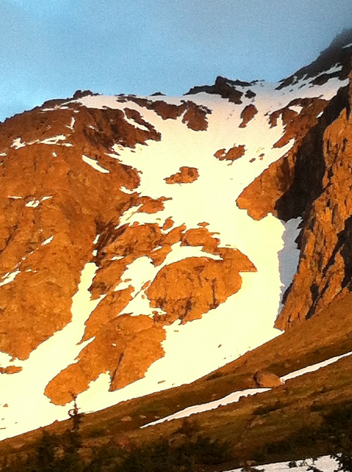
The big winter and cool summer in Anchorage has the Ptarmy in good shape. It is still possible to ski from the ridge and the cruxes are still relatively wide and deep. There was 2-3" of soft on top of very firm. Long fall line mini-ridges of extra firm snow / ice are aligned in neat rows. These ridges are 2" high x 2" wide x 100's of feet long about 3-4 feet apart. It makes for a bumpy ride which is nicely contrasted with the spray from the top few inches of soft snow. Click for the moving pictures.
So choosing between unleaded, supreme, and diesel, I give today a diesel. Ricky gives further explanation of this odd rating system.
- U.K.
Sunday, August 5, 2012
Sunday, July 8, 2012
Colchuck Glacier

It’s July and the heat is on in central Washington. Climbing and rafting has been great
this spring, as another couple boyz can attest to, but the need to ski has gone
unsatisfied for too long, and with the temperature on the rise Lizard and I
were afraid we might have brought our skis up to Washington in vain. We had to let ‘em ride on some Cascade
corn before the summer is over.
S-Bomb rolled into town with the urge to shred and it was on. Plenty of snow left in the upper
elevations with some friends claiming ski descents of Mt. Daniels and Steven’s
Pass area the week before. Our
plan was to climb to and camp at Colchuck Lake, ski the glacier and possibly tag a
summit. Liz and I were also hoping
to use the trip do some recon on the numerous alpine routes in the Enchantment
area.
We left for the lake on Tuesday, making short work of the
trail.


Lizard is trying to catch a fly!
Greeted at the lake by cold rain and mist, skipping around
on granite domes amidst pine and fur forest, it reminded me a lot of the
Whites, except for the towering granite mountains of course.

Dragontail Peak, with Colchuck Glacier lookers right

Colchuck, glacier on the left, peak on right, shrouded in mystery
The next day dawned clear and beautiful. Our pace was relaxed and our spirits
high, a leisurely start of 10ish brought us to the col by, well I can’t
remember.

The way up, with plenty of boulder caves for an un-permitted bivy!

Stair master to the Sky
A quick scramble up the
snow and boulders to the summit of Colchuck peak rewarded us with amazing views
of Stuart, Sherpa, and Argonaut peaks to the north, as well as Dragontail’s
Backbone, and Serpentine ridges just across the Glacier to the south.

Liz, Sherpa, Mt. Stuart, gnar couloir anyone?

Ladybug hatch on the summit
A few pulls from the flask and we headed back to the Col to
begin the shred.
The descent was sublime, almost 3,000 feet of continuous
pitch right up to the edge of the lake. A little suncupped towards the lower elevation but
otherwise soft and fun.

Loving it

Trying to spray some climbers

Making turns and taking it all in under the sheer wall of
Dragontail.

S-Bomb flapping the wings, CAW!

Lizard letting em run
The hike out was a bit of a slog, tired legs and the
unwillingness to stop and become mosquito food kept us pounding all the ways to
the beers at the truck.

Confuscious say, think rike a forest.
A beautiful trip with great friends, stoked to make some turns in July!
Cheers,
Shagnasty
Wednesday, June 27, 2012
Early Summer Round Up: AK and UT
The Noodler is still charging the Front Range above Anchorage. He sent this quick dispatch from the field for a recent bike-hike-ski of the Ptarmigan Couloir ("S" Couloir):
Sun cups were small and soft.
2" ski penetration.
The lower half was peppered with small surface rocks.
3 small portages to ski to the bikes.
7 short portages with the bikes over snow.
Super fun.
Aim to ski after 11pm for maximum sun exposure.
I want to go back ASAP.
 |
| "S" Couloir at Night |
Gremmie and at least one Brefan have been out climbing around Utah. Check out the climbing in Lone Peak Cirque above SLC and some desert towers: click here
Over the weekend I made the drive to Hope, AK for some skiing and live music. The recent weather has been unbeatable with endless daylight under cloudless skies. The drive along the Turnagain Arm never gets old.
 |
| Pyramid Peak from the Seward Highway |
 |
| Explorer Glacier and Carpathian Peak above the Turnagain Arm |
 |
| Lower Palmer Creek (6/23) |
The drive is a buffet of awesome skiable gullies on either side of the road; the road is bridged across the creek in two places so there is really no need to ford the creek if you see something you like: just keep driving / walking until you are on the "right" side of the creek.
 |
| Upper Palmer Creek (6/24) |
At the Mile 10 gate there is a parking area could hold about 8 vehicles and is just above tree line so cruising around up here is easy no matter the season. There are also several mining roads and trails that can get you up to some nice lakes and higher valleys.
 |
| Cruising Out |
I hope your summer is off to a great start and that all of your wildest dreams come true!
- U.K.
Friday, June 22, 2012
Solstice Couloir: June 20, 2012
It was the Solstice so it was off to schuss the Solstice Couloir. Town was sunny but the mountains were super socked in, but there was no other choice.
The Solstice Couloir is accessed via the South Fork trailhead up Hiland Road in Eagle River. Basically aim for the notch (Hunters Pass) above the car park. From the notch follow the ridge up-canyon to the summit of Peak 3980. I've made this hike maybe 20 times, but this was the first time in a cloud.
 |
| The bottom 1/3 of the Solstice Couloir |
The vis was zero, so I let Jesus take the wheel. The gamble paid off and after 75 minutes I was rewarded with a majestic view that could best be compared to the inside of a ping pong ball. But there was good news: the snow had finally changed to névé - summer snow: fast, smooth, and consolidated! The sun cups are still in their infancy; the skiing was excellent.
Mid-winter, you can milk this shot for a good 2,100' by sussing private property onto a road below the trail head. Today, it was good for 1,500'.
 |
| The End |
From the bottom of the snow, simply stumble down fall line until you hit the South Fork Trail. Due to recent work, this fresh scar across the hill side is impossible to miss. Once you hit the ATV road it only 1 mile back to the car. Easy peasy! And this line will be skiable for the next couple of weeks. So if you have the itch but not the desire to spend all day hiking, keep this shot in mind.
 |
| Looking up the Solstice in 2009 (note the dark ash from the Mt. Rebout eruption) |
- U.K.
Monday, June 11, 2012
Mountain Hood....The Great One
 |
| 8s Below the South Side |
 |
| Yourz Truly Mid Spur |
 |
| Moon Beamz Summah Home |
 |
| Mid Sunshine Route Mandatory Air or Abseil |
 |
| L to R..Coopers Spur, North Chutes, Sunshine Rt |
 |
| Cooper Spur, North Chutes, and the Sunshine Rt on the Skyline Ridge |
 |
| South Side Hood from the top of Wy'East |
 |
| Crater Rock with Illumination Rock Below on the South Side |
 |
| Skiing the Wy'East |
 |
| Leuthold's Col. |
 |
| Dick McRippington midway down Leuthold's |
 |
| Exiting the Leuthold's Col. |
 |
| Even Dogz climb the Hoodwand....above the sharty is the Pearly Gates |
 |
| Buffalo and Scriv climbing up the Old Chute on the South Side |
 |
| Dick McCruxington on an attempted ski descent from summit to Wy'East, a little less snow than expected |
 |
| Jake and Scriv after navigating the Wy'East directisimo |
 |
| About to ski the Wy'East Infection aka Glewstick Col. varation of the Wy'East |
 |
| A jibonkity below the West Crater Rim Castle Crags on the South Side of Hood |
 |
| Reid the Fuckin Book....your nothing without it. |
 |
| Base of the Reid |
 |
| Mr Shartz ripping the Sandy Headwall |
 |
| The Sandy Headwall Choke |
 |
| Teen Wolf getting through the choke on the Sandy Headwall |
 |
| On the return from skiing the Sandy Heady Wall, which is on the lookers left. |
Here is a list of the skiable routes starting on the South side of Hood, which is the main climbers route to the summit of Mountain Hood. The list goes clockwise from the summit. The Pearly Gates, Old Chute, West Crater Rim, Reid Headwall, Leuthold's Couloir, Sandy Headwall, Sunshine Route, (*North Chutes* unfinished), Cooper Spur, Newton Clark Headwall, and the Wy'East.
The Pearly Gates- The most direct line down the south side from the true summit. It has a tight choke that can be kind of dicey, usually filled with ice. When I skied it, it twas butt puckering. You can take this down the White River Glacier and milk over 5,000 vert.
The Old Chute- Probably the easiest skiable route from the summit. This is also the main climbers route to the summit of the Hoodwand. Its like 40-45 degrees or so maybe steeper depending on snow conditions. It mellows out steepness wise pretty quickly. Its a great place to scare the shit out of bumbling climbers. Skiing above climbers is one of my favorite hobbies. You can take this down down the White River Glacier, the main climbers route, or skirt over to the lower half of West Crater Rim.
West Crater Rim- Probably the coolest route down the south side of Hood. Go up the Old Chute, head west on the summit ridge, and drop in between the rime ice towers for a descent back down the southeast facing side. You can scope this line as you ascend the main climbers route on the south side. This line has wicked cool exposure as it seems like you are skiing off the edge of the world when it rolls over to about 50ish degrees. For those of you from the east its like skiing Tuckerman's Headwall, as the shit rollz over big time. Yikes! You can take this down Zig Zag glacier and traverse back to the Timberline Lodge.
Reid Headwall- Pretty steep line that you need to do early in the year before it runnels out. Later in the day too because its west facing. Its a super aesthetic chute lined with rime ice cliffs. If you ski right up to the the Castle Crags on the South Side and drop west your are in it. Watch out for the shrund at the bottom.
Leuthold's- Another great line. Not too steep, just one choke near the bottom and a shrund. Go up the Old Chute, head to the summit ridge and go west. Descend west down to the prominent knife ridge called Yokum Ridge. You can either keep descending west down the Sandy Headwall or drop south southwest down the obvious chute to the skiers left of Yokum Ridge.
Sandy Headwall- What a killer line. Super aesthetic 3,000 foot headwall. This face is looms over the town of Portland. Freekin awesome and a must ski. There's a choke that can be difficult. Bring a picket and a rope in case you can't send it clean.The upper part is a pretty consistent 45ish degree pitch. The choke can get a bit steeper depending on conditions.
Sunshine Route- 3,500 foot killer run down the pristine north side of the Hood. There's a couple shrunds that open up which you might need to air or lower over. I've skied this twice and it was between 10-20 foot huck or rappel. To find this, descend down the west side of Hood from the summit and look for the first obvious entrance down the north side. You can follow a prominent ridge to the base of the Elliot Glacier. Have a car stashed at Cloud Cap or traverse back around the east side of Hood and descend back to the Timberline Lodge. This take about 4 hrs.
North Chutes- Man Ballz
Cooper Spur- Steep as fuck, cool as hell. Drop off the summit and impress the bumbley mountaineers on top. They will think your fuckin nuts as it looks like your skiing down a sheer cliff face. Don't fall, this is the deadliest climbers route on the mountain. I think 13 people have died falling on this route. Jumpin jahsofat!!!
Newton-Clark- Great down the east side. First skied in 1937!!! Badass line, not too steep but steep enough to tighten yer sphincter.Go up the Wy'East and look for the next prominent line as you head toward the summit on the prominent ridge. You can sometimes access this from the summit on good snow years.
Wy'East- Great line. You can ski this to the Meadows or rap back around and ski to the Timberline lot. Not too steep, but really cool. Go up the Palmer to the top of the resort, cross the White River Glacier and head up the prominent ridge. Its not to steep until the top where it rolls over to 45 degrees. You can also climb up directly from the Meadows ski resort
Well I hope you enjoyed my beta and pics. Hope you get out there to do some Dick McSchraplington on the Hoodwand.
Cheers,
Todd Glew
Thursday, June 7, 2012
The X Couloir: June 4, 2012
Looking at the weather forecast on Sunday, it appeared that Tuesday would have the best weather. I had a few ideas of what to attempt, but half-heartedly decided on the X-Couloir.
A cloudy Tuesday morning transitioned into a brilliant afternoon. Today would be my best opportunity to go for this bigger objective. I blew out of work at 2:30, biked home, and loaded up the Taco, and was hiking by 3:30.
The X Couloir is on the North side of Mountain Peeking which is about 10 miles up Peter's Creek. Typically this is accessed via the Ram Valley trail and then taking a left on the Falling Waters trail. Legal access to Ram Valley definitely falls into a grey area because of private property issues. It definitely helps if you know someone who has land adjacent to the CSP.
The start of the hike was super nice amongst the Alaskan Lupine and budding trees. The trail was dry and snow-free high into the Falling Waters drainage. At about 3,500', I swapped out the approach shoes for boots and started skinning. Falling Water is a serpentine drainage that zigs and zags.
 |
| Route Up the Winding Drainage |
 |
| Raina from the Top of the X |
From the col (6,100'), I got my first look at my descent route. It is wide, but long and steep (~ 40°, 2,200'). The shot is 100% North facing and was still completely in the shade at 7:30 PM. At some point in the prior week, the snow in the couloir got well above freezing and then froze solid. Dropping in, the snow was bullet-pack. If the surface was smooth, only my edges would be preventing a slide for life. Fortunately, someone had skied the shot when it was manky which roughed up the surface considerably. Jump turns down, down, down, aiming for the trenches and high spots left frozen in place by an unknown benefactor. The angle refused to ease. At the nexus, I had a choice of which leg to descend. The narrow left was about 10' wide, but the snow was still very firm. This time I decided to "Choose the Right." In the lower half, the snow began to soften, but it was a mix of runnels and avalanche debris. I aimed for the smoother sections and got some decent turns as the angle finally began to ease.
 |
| The X: Skied Top Right to Bottom Left (Note "W" shape on the ridgeline) |
At the top of the 1st 1,000' climb, I sussed out my descent into the next basin. I had expected to ski this section, but it was 90% melted out. It wasn't ideal, but it didn't look too bad. I planned to down-climb to a narrow band of snow and then sideslip all the way to the floor of the next cirque. See #1 in the photo below.

At Point 1, the snow looked super sketchy. I was hoping for consolidated neve, but what I got was fully saturated slush somehow clinging in place. This was beginning to look like a bad idea. I took my skis off my pack and hacked at the snow pack with my tips. This released the slush / snow to the ground and it accelerated down the slope moving with the consistency and the roar of rushing water. As the slide ripped down the gully it was gathering debris and more snow. The snow only ripped out only as far as I was able to slash with my tip (about 10% of the snow width). What did rip, ripped to a frozen wet tundra bed surface.
The downclimb had already been steep, but with the promise of 4 edges I was confident getting down to Point 1. Now that skiing was out of the question, the down climb became much more serious. My skis were already off the pack. I decided that the increased freedom of movement was more valuable than my 3-year old spring rock skis. So I hucked them down slope in the hope that they would find their way to the valley floor. They stopped at Point 2. Buh-bye.
I followed the Red Line (line added with iPhoto - not actually present in real life) down to the next snow patch. At this point I realized I was above a massive cliff. Fuck! But I was able to spy a goat path traversing above the cliff band. Goats are typically smarter than me, so I put my trust in these intellectual superiors and aimed for their route.
Crossing the wet frozen slide gully at Point 3 was nerve-wracking especially since I was now aware of the large cliff below. There was only 1 crucial step so I got some momentum to carry me across in the event of a slip. The foot held and I was across. I worked my way down to the goat path at Point 4. This was no guarantee that this path would lead anywhere, but it was my best option.
Goats have massive balls; balls that clank, that's for sure. This 6" wide path skirted less than 6" from the edge of the cliff. The path would be easy if it were in a nice grassy meadow, but exposure has a way with fucking with you. I moved with purpose and tried to block out the void that the ski pole in my right hand was suspended over. And after the longest 20 seconds in recent memory, I was on an island of safety.
The route to the valley floor was now obvious and after a quick glisade I had made it. Thank God! Thank you Adam, Sroga, Roberta, Memere, Jane, and all of my other guardian angels. There was still another 1,000' of climbing, but could see the entire route and had already sussed out the descent into Falling Waters. The worst was now behind me.
 |
| My Route: Far Right Preferred Route: Far Left |
 |
| Expert Route Finders Enjoying the Sunset: 10:30 PM |
 |
| Polar Bear Peak: 11:00 PM |
 |
| Sleeping Lady and the Knik Arm: 11:30 PM |
- U.K.
Subscribe to:
Posts (Atom)