Monday, November 1, 2010

Snowbird Glacier: October 30-31

The report said they had groomed the Nordic area at Hatcher Pass. I assumed that this meant there was enough snow to ski and made the drive up to the Talkeetna Mountains with plans to suss out the new Snowbird Hut.

There was only about 2" of snow at the turn-off for Archangel Road and I was surprised to see that the gate was still open. I started hiking from the Reed Lakes Trail Head. After about 1.5 miles you come to a dilapidated cabin. Here you turn left and begin the 2500' climb to the pass. There wasn't enough snow to skin but enough to make every step a surprise. There was 18" of snow at the pass; more than enough to ski this glacier.

The American Alpine Club built a brand new hut with donations and volunteer labor. I attended a kegger/fundraiser in the Fall and knew I had to see it for myself. The hut is perched on the lateral moraine on the skiers' right. The old hut is still in place and is usable for this winter. There are plans to remove it next summer.

The Huts

View from the New Hut

New Kitchen


New Bunks


There is plenty of gear stashed in the hut. No need for a sleeping pad or a stove. There are nice well-used sleeping bags and booties, but I was glad that I had my own. The cook stove runs on white gas and the heater runs on diesel/kerosene.

After getting situated in the Hut, it was time to kick off my 36th consecutive month/36th season. The glacier is really a wide ass "blue square" run, but starts getting steep as you approach the 6,000' ridge. I wanted to gain the ridge to see if it was possible to link up with the Lane Glacier for a potentially easier way back to the car. The route was marked with small crevasses so I opted to stay close to the rocks. I couldn't tell if I was on glacier, solid ground, or hanging out over the moat. Pole probing revealed that there was solid ground/ice under me and I turned my attention to snow stability.

There is 36" with 1/4" surface crust at all elevations/aspects with hoar frost developing. From a safe spot, I stomped the snow with a ski. Whooooph. Shooting cracks and sympathetic cracks 15-20' below me. Steeps are touchy. Copy.

From my aerie, I de-skinned at got the Hell out of there; back to the hut, back to the beer.

The next day I got in some nice low angle love. The crust was catching the wind and attacking my face. The skiing was decent, but the scenery was amazing. Thanks to all the volunteers and donors for providing such a comfortable place in this spectacular location.

-GOB

Saturday, October 23, 2010

Cotopaxi: October 13

I made it back to Quito safely for beers with the translator.  Over the next two days we climbed Pichinca Rucu (15,413') and checked out Pasachoa National Refuge.  That afternoon it was time to make a move towards Cotopaxi.  We parted ways at the bus stop in Amanguana.  High fives and thanks.  That CBrown is a good one.  

I hired a pick-up to drive me to Papagayo Hostel in Machachi.  Papagayo is rad; they have a petting zoo, puppies, white linen dining, a hot tub, internet, TV, and dollar beers.  This runs $20 a night.  Meals are in the $3-$7 range.  

The next morning I met my guide, Fernando.  Fernando lives at the base of the mountain and stopped counting Cotopaxi summits last year when he hit 200.  He also has climbed in Peru and the Alps.  This was a good sign.  I was outfitted with mountaineering boots and clamp-ons and we hit the road for the park.  

From Papagayo it is about 30 minutes to the park entrance and another 30 to the high parking lot.  We raided a small grocer on the way for supplies.  There are no ClifBars, no trail mix, no Goo, no Blox, just candy bars, doughnuts, and Coca Cola.  I like this place.  
 
Park Entrance (Fee $10)

Refuge and Cotopaxi from the Parking Area

We parked at 14,700' and hiked with full packs to the Refugio P. Jose Ribas de Reina at 15,800'.  It felt good.  The refuge can hold about 100 people and I hear it fills up for a rocking party on New Years.  Pounding booze at 15,800?  Well, that wouldn't even be close to the dumbest thing I have ever done. Tonight there were only 7: 3 guides, 4 clients. The refuge has bunks stacked 3 high with thin mattresses; bring a sleeping bag. The kitchen is communal with a propane stove. There are plenty of pots, pans, plates, cups, etc.  

Fernando whipped up an awesome chicken cacccitore pasta which is no small feat considering water boils at 175 ˚F.  He laid out the plan: hit the sheets at 7:30 PM, get up at midnight, hiking by 1:00 AM, summit by dawn.  Copy.

In Ecuador the sun rises at 6, is directly above you at noon, and then sets at 6 everyday of the year.  And when it sets, it is dropping straight down; not much time between sunset and dark. What dusk lacks in duration, it makes up for in intensity.
    

Midnight finally arrived.  I spent the short night tossing and turning.  We hit the trail at 12:53 AM.  There's one group ahead of us, but that won't stand.  The 1st 1,200' vert is loose gravel.  Its like trying to climb a sand-dune.  Each step pays 6" but then is promptly fined 3".  I struggled unsuccessfully to find better purchase.  This is more work than anticipated.

Fernando said it would take an hour to reach the ice.  After exactly one hour we reach the ice. I wanted to beat his estimate, but it was not to be.  Getting the clamp-ons affixed to the boots allowed for a bit of a breather and a chance to admire the stars.  Many stars.  Quito stretched out to the North and seemed to sprawl on forever.  I tied in and we started in on the ice. The hard ice made me nervous, but after about 10 minutes we were on snow and feeling comfortable.   

Cotopaxi is climbed often.  The trail is beat into the snow and is about 2' wide with no side hill action.  It is not that steep, but traverses some steep faces with consequences.  I check my grip on my axe often.  The ascent is just a slow march.  Large amorphous shapes loom all around. Black chasms close just before the trail and open wide on the other side.  

At 18,000', Fernando informed me that the ice bridge has melted out.  Route-finding ate up about 30 minutes. The crux of the detour ended with Fernando sending it over a snow bridge and booting up a 50˚ slope for about 6 steps in 5 seconds flat. Fast and loose. Nice! This guy was getting it done.  I repeated the Skier Boyz mantra and went for it.  

Back to the grind. Foot step after foot step. One minute I was done, the next I found my wind. My head was starting to hurt.  My muscles weren't tired, but I just couldn't muster the energy. We were traversing above something big and I was getting the dizzies.  

"One minute."

"Not here, 100 more meters."

"OK"

We were through and took our first break. Ten minutes later Fernando was moving. OK, OK. More of the same, but then the trail narrowed and then narrowed again. It traversed a steep slope and disappeared around a corner.  Cotopaxi is a very symmetrical cone.  There are no major ridges.  The route is a series of traversing faces and getting on short minor ridges and repeat. This latest traverse got about boot wide. I was having trouble getting my inside foot in front of my outside foot. It was light enough to see around us, but I chose not to look.   

"Nothing's gonna happen"

"Que?"

"Nada va a occurrir."

Mercifully, the ledge rolled into a ridge which quickly transformed into a climbing narrow traverse across a face.  Boot wide again, but it felt narrower.  Fernando was around the corner, keeping a tight belay.  I really better not look at whatever this is.  Getting my inside foot around was becoming a problem, so I tried a technique from a popular movie.  It worked.

And again back to a ridge, but this one was different.  It started to roll over.  I could see low spots on the crater rim.  The sun had just risen and pink light was dotting the landscape. I could smell sulfur wafting over us from the crater.  Minutes later there was nothing left to climb.

Cotopaxi's Shadow over Las Ilinizas 

Summit Crater

After 15 minutes the 2nd team made the summit.  Smiles and high fives and exhaustion.  The sun was heading straight up and warming things quickly.  We couldn't linger.  Snow bridges would soften, ice would fall.  We made quick time.  The large dark shapes from the hike up revealed themselves in the light.  Generally things looked beautiful and terrifying, but our little trail snaked to and fro avoiding all of the obstacles.


We hit the refugio after 2.5 hours for some rest.  My head was killing me.  I finished my water and chocolate.  The other team of 3 wasn't fast enough and had to turn back because of softening snow.  You really have to hit it and quit to make the summit.  A good guide is a wise move especially if there is new snow.  Call Papagayo and ask for Fernando.  Months of training was critical to my success.  Without the help of hiking parter DBass and altitude coach CBrown, the summit would have been elusive.  

And since you read this far, I will answer the only question you care about:
The snow is ass; leave the skis at home.

- Doyle Hargraves
Thursday, October 21, 2010

Las Ilinizas: October 9

My translator was gone.  I was on my own.  It was time to see if I could navigate this country solo.  Cab to the bus station: easy.  Bus to Machachi: stressful but got it done.  Now where is the bus for El Chaupi?  Fortunately the people of Ecuador are the nicest people ever.  I must have looked out of place because I was getting plenty of unsolicited help.  

Along came a bus straight from Imagination-land: bumping music, brightly painted, tassels on the curtains, license plate that said "Fresh", and there were dice in the mir'.

If anything I could say that this bus was rare, but I thought, nah, forget it, yo home's, to El Chaupi!  

The ride set me back $0.41 but I would have paid $0.45, so I was feeling pretty good about myself.  The hostel was only a few blocks uphill from the town square.  I had booked a private room at the Illovizno and opted to include dinner and breakfast ($25 all in).  This place is a climber's hangout.  Stickers from climbing stores from all over the world plaster the windows around the entrance.  Flags and old climbing gear fill the mantel over the fire place. The main food staples in this part of the country are chicken and potatoes and plenty of them. Dessert was tomate de arbol (tree tomato).  It was sweetened, baked, and served warm. Fantastic. My room was drafty but the covers were heavy.  Perfect sleeping weather.


The Hostel

The owner, Bladimir (with a B) Gallo arranged for a 5 AM wake-up, breakfast, and a ride up the 10K cobblestone road into the park to the trailhead.  He also insisted that I borrow a climbing helmet and gave me a 2-way radio in case I ran into trouble.  See, these Ecuadorians are awesome.  

The trail starts at 12,800'.  It starts gradually climbing through what feels like high desert.  The elevation (altura) wasted now time kicking my ass.  I had left my fancy watch back in Quito so I was unsure of the elevations for the entire hike.  

Sur on the Left, Norte on the Right

I had planned on climbing the North Peak, but I was on a sub-ridge heading towards the South. The gully separating the two was deep and narrow. This didn't feel right, but I didn't have the energy to do anything except slog on up the trail. Closer and closer to the wrong mountain, but as long as the pass was above me, I wasn't going to worry about it. Finally the trail took a hard right and headed towards the pass.  The hut came into view; I had chosen the correct route. Phew!  The hut costs $15 a night and has a propane stove.  They sell beer ($1.50) and other hot and cold drinks for about $1.  


The Refugio (15,400')

The South peak has plenty of ice and requires technical gear. It blocks the weather for the North; so no ice on the North. So North to the future. I gained the ridge and was making good time.  

The Route to the North (16, 818')

The South

Eventually you need to get off the ridge and traverse onto the face via El Paso de la Muerte.  With a name liked that, I assumed this would be the crux.  I breathed a sigh of relief on the other side even though it was only 3rd class.  At this point you need to trascend across the face until you are under the 2nd (higher) summit.  This was considerably more difficult than the Pass of Death.  There were some low 5th class moves and the sun was starting to change the frozen mud into slickery mud.  Where is Vonnegut's Ice Nine when you need it?  Careful placement kept my feet on the rocks and my shoes dry.  The hedgehog could smell the summit. 

The last 100' vert is an awesome super juggy 4th class chimney. Prefect hold after perfect hold, near vertical and then no more. An iron cross marks the summit, well that and thick clouds. No visibility, but that was fine. Ain't nothing going to break my stride, nobody's gonna slow me down.  I rested and after about 5 minutes the clouds broke.  First some valleys, then the South Peak, and then Cotopaxi! I lingered trying in vain to take it all in.  No words to describe it. Poetry. They should've sent a poet.
  
Cotopaxi from Iliniza Norte

On the way up I sussed a big time short cut.  Send it right down the East Face, all scree.  No Death Pass, no mud, just 2,000 vert of beautiful scree.  Hallelujah!  This I know.  4 hours up, 2 hours down.  "Blad, come and get me, over, copy, 10-9, come again, roger!" 

It was my highest peak ever.  The elevation didn't crush me as much as I expected, but Cotopaxi concerned me.  Its 2,500' higher, glaciated, and looked terrifying from Las Ilinizas.  There'll be time to worry about that later, now it was time to negotiate buses and taxis and pick-ups.  I needed to get back to Quito to meet my translator for beers.  

-Crixus

Tuesday, October 19, 2010

Monday, October 18, 2010

Ecuador!

Just returned from a very successful 2 weeks on the Equator. It was terrifying and exhilarating. Never have I been more scared or more excited.

Ecuador is on the US dollar so that part was easy. They speak Spanish; that was a bit more difficult but my Spanish was just passable. Their wanton disregard for highway safety was the toughest aspect to get used to. Those hombres straight up send it on every highway, alley, dirt road, and city street. Terrifying. My advice is not to look and let the drivers do their jobs.

Why Ecuador? The beauty, the culture, the people, the mountains, the experience? No, no, no, no, and no. Liftie extrodinaire CBrown of Bridger/Alta/Alyeska fame is a the beginning of a 10 mounth diplomatic mission of cultural exchange. I was hoping for a free couch. Check out her blog for indepth analysis of all things Ecuador:

http://cbrowninecuador.blogspot.com/

I'll post trip reports for Iliniza Norte (16,818') and Cotopaxi (19,347') later in the week. For now, please enjoy these photos:

Top of Cotopaxi

Sunset behind Las Ilinizas

Cotopaxi from the Highway


Pickup Soccer: The Basilica, Quito


Zimbahua

Friday, September 24, 2010

September 23: Byron Glacier

In '07 and '08 late September brought piles of new snow. The early snow stacks up quick on glaciers, and the Lane Glacier is the place to be. Last year late September brought only about 8" of snow and the skiing was rough, dangerous actually. I figured 2009 was the odd-ball and September 2010 would return to form, but this was not the case.

Indian summer persists and is forecasted to stick around into October. This stretch of weather has been incredible: no wind, no clouds, cool nights, and warm days. The hiking has been great, but I had a streak to think about. August was month #34 and I wanted to keep it going.

A few weeks back I was hiking in Portage and noticed some small aprons of snow not too far from the road near the toe of the Byron Glacier. I needed to make a Girdwood run Thursday after work for some boot repair. Since I was going to be in the area, it would be a good opportunity to check out those small aprons. Hopefuuly there would be something worthy higher up on the Byron, but the aprons made for a good plan B.

From the trailhead the glacier and aprons are clearly visible. Byron was scantily clad and not very appealing, but the aprons were looking better than expected. The largest apron still had a 10' thick snow bridge over the creek.

"Ah, what the hell, I'll boot that."

The tops of the sun cups were pretty soft, but the bottoms were still firm. This might be fun. After 350' vert, I had topped out. That's bigger than some of the resorts I skied back in the Eastern Masatch. It took about 15 minutes to kick in a suitable flat spot to click in. The turns were about as good as expected and I was quickly at the bottom.

The booter was in so, "Ah, what the hell, I'll boot that again."

This time I cleared the route of rocks, hucking them to the side. Click, click, and down. It was starting to get better, smoother, softer.

"Ah, what the hell, I'll boot that again."

Not so bad.

"Ah, what the hell, I'll boot that again."

I was getting used to the snow and actually curved some turns and making nice transitions.

"Ah, what the hell, I'll boot that again."

This time I shouldered my skis in honor of the one that shoulders his skis. The turns were good, but this was getting silly. The alpenglow was peaking and dark would be creeping in soon, so it was back to Anchorage to prepare for another day in the cube. Who knows maybe I'll be back tomorrow.

- Black Larsen


The Byron Glacier with the Offending Apron in the Foreground

From the Top of the Apron Looking Towards Begich Peak and Portage Lake

Tuesday, September 21, 2010

September 18: Bold Peak (Hiking Edition)

Anchorage has been socked in with fog this last week. It's similar to the SLC inversion: crap low, bluebird and warm up high. And its gonna take a significant system to break the pattern. With the promise of good weather; it was time to go after one of the Chugach State Park's big dogs.

Bold Peak is a giant rising over Eklutna Lake to an elevation of 7,522'. Its not technically difficult but the long approach and big vert make it daunting. Getting to the bottom of the climb is straight forward: bike 10.5 miles down a campground quality dirt road next to the lake. Stash the bike at the junction, take a left, hike about 20 minutes until you get to the 3 cairns at a small creek.

Now the uncertainty begins: 6,700' vert in 3 miles consisting primarily of scree. Awkward scree. Embarrassed and uncomfortable scree. It wouldn't stay put on the way up and won't slide on the way down. It gets good for sections but never for very long. It made me very self-conscious.

Even with the overpowering awkwardness, I made good progress and was at the high pass right on schedule. The summit looked close from here but the map tipped me off that its actually over 2,000' higher. I rested, fueled and sussed potential routes.

"I think I'll head straight up the middle of the mile wide patch of awkward scree."

I summoned my spirit animal (the great white buffalo), put my head down, and pushed into it, trying not to make eye contact. Fatigue crept in and my pace slowed giving me the opportunity to savor the rapidly improving backdrop. Holy shit, that's Marcus Baker! It just kept getting better and better. There's the Eklutna Traverse. Redoubt. Neacolas. The entire Talkeetna Range. Dozens and dozens of Chugach glaciers. Each step higher made my jaw drop a little bit lower. Despite my deteriorating pace, the summit eventually yielded and the Alaska Range from Spurr to Denali was in my lap. All the awkwardness was gone. It was like I was using Axe body spray.

I lingered up high trying to take it all in. I changed my aspect often swapping one mind-blowing vista for another and then another. No clouds, no wind, and warm. Nice enough to forget about the record setting rain this summer. I looked at my watch and I knew that it was time to descend into the unpleasant and humiliating scree below. But I had gravity on my side and a renewed sense of self-confidence.

"I'm good enough, I'm smart enough, and gosh darn it, people like me."

-Stuart Smalley


Eklutna Lake 6,700' Below

Alaska Range

Eklutna & Whiteout Glaciers


Bold from the Parking Lot

Monday, September 20, 2010

North Slope, AK: September 13-16

After a long rainy summer, Alaska is finally getting some awesome weather. Just a couple of shots from a recent work trip up North.

- Charlie Watts

Arctic Sunrise

Sultana and Denali


Wednesday, September 15, 2010

September 9-12: Adak

"You wanna go to Adak?"

"Sure, where the hell is that?"

Adak is an island in the Aleutians about 1200 miles SW of Anchorage out in the Bering Sea. The Aleutian Islands  are small and dramatic; some are heavily glaciated.  Adak was the site of a Navy base that closed in the 1990's.  At its peak there were 6,000 seamen there.  As you all know the Navy is nothing  if not generous.  They are like Santa.  Karl, for you we have an incessant dry cough. Adak, you've been very good this year.  You get this massive military infrastructure, six 3,000,000 gallon tanks, 1,500 abandoned 4-plexes and a rec center.  Have a few cold war spy buildings for good measure.  You're welcome.
  
Now about 100 folk occupy the rapidly decaying town.  

Back in January, the local fuel man overfilled one of those 3,000,000 gallon tanks.  Fuel filled a creek and worked its way to the ocean.  This attracted the type of attention Adakianistas like to avoid.  This is where Detection Milton (myself in the 3rd person) comes in.  My boss wanted to know what happened and put me and JH on the case.  To prepare, I used all of the resources at my disposal: google earth and wikipedia.  Damn, there are 2 volcanoes over town. Shit, that berg has a maritime climate.  They get their water from Lake Bonnie Rose.  Armed with all the knowledge necessary, the Rad International Investigation Unit boarded a 10% full 737, slammed a complementary Canada Dry Ginger Ale, read the airline's magazine, napped a bit, and touched down in glamorous Adak.  It was time to crack the case. What I found was shocking.  

This island would be a multi-sport mecca if not for its extremely remote location and the Notorious B.A.D. weather.  I was fortunate enough to catch 2 out of 3 days of nice weather.  The one day of  rough weather stepped it up a few notches: the hurricane force Bering Sea gales didn't even have the courtesy to simmer during the 5.4 earthquake.  But, man, nothing beats a beautiful day in the Aleutians: completely mind blowing.  This island has epic mountain biking, skiing, kayaking, hiking, halibut/salmon fishing, and there was even a decent crag in the center of town.  Moffet rises 3,800' above town and was still sporting skiable couloirs.  The dirt roads that snake all over the island are perfect for some high speed mountain biking.  There has to be  at least 17 main kayak trails.  All of this on an island the size of Nantucket.  The next closest island is Great Sitkin which sits about 2 miles from the North Shore.  G.S. is half the size of Nantucket and has a 5,710' glaciated volcano.  Take that!

But reality can be a son-of-a-bitch: 311 days of rain, $1200 flight from Anchorage, $37 18-packs of MGD. Despite these obstacles,  I can't help but think what could be accomplished if you nailed this rock with about 7 days of blue-bird.  

-Milton Arbogast

1,200' Hill on a Bering Sea Beach

Even Lakes

Mount "Barb" Moffet

The Great Sitkin Looms

Sweeper Cover

Monday, August 9, 2010

August 8: Ptarmigan Couloir

We have had a crap summer.  So much rain and grey, arrgh!  But Sunday brought sun.  I was blinded.  After letting my eyes adjust to the seering intensity of partly cloudy, I made my way to Glen Alps above Anchorage with the same plan as last year: bike it, hike it, boot it, suffer down it. 

DB Noodler had given rave reviews for this ski run just 2 weeks earlier so there was reason to be optimistic, but there is always doubt.  The run is hidden from the trailhead so I summoned up my all my faith and let Jesus take the wheel.  The approach parallels power lines along a gravel road that is closed to motor vehicles.  Soon the shot was in view and I knew something was gonna happen.  

After stashing the bike, I had to scramble up 500 vert of loose scree.  At the snow line it was time to boot up.  Hey look!  The Garmont is missing the critical ankle bolt.  This semi-functional boot will compliment my other semi-functional boot with the torn shell.  Despite this, I made good time.  The slope was in the low 40s and I felt comfortable with my toes in about 1" and when I needed rest (often), the snow was perfect for kicking in a foot sized ledge. 

Rock fall seem to be fairly common here so I stole a page out of MJ's playbook by removing the rocks from the snow throughout the climb. The walls were towering above me on both sides and I was thoroughly enjoying the afternoon.  Then it got weird.  THUD, and and about a dozen small rocks, a bit of a shake, and huh....  What in the Sam Hell was that?  4.1!

Shaken not deterred, I continued up.  It got narrow and then opened into a wider section with decent snow.  Above the wide section there was a tight choke heading to the ridge. I decided that the wide section would be more appropriate given my busted boots, shot nerves, no turns for a month, and rolling solo.  It would be a good warm up for the "crux" below.

The sun cups were 2-3" deep, with only about the top 1" coming off on each turn.  Not ideal but fun.  I got into a rhythm and kept it through the choke.  The snow got dirtier and firmer.  It was tough to hold an edge and I was in no mood to fight it at this point.  I skidded lazily through my turns getting a free foot massage from the wash board "snow."

That was .... interesting.  I took my time on the hike down and eventually made it to the tundra. It looked like rain was on the way and I was glad to have gotten the window.  And what to my wondering eyes should appear?  That's right! A bottle of Kokanee Gold laying in the tundra; label bleached silver.  Dare I hope?  Could it be?  Madre de Dios, the legends are true!  Actually it tasted awful, but a free beer is a free beer.  

- Andreas Baader


(click for a better view of the squiggles)


Saturday, July 17, 2010

Cooper Spur

With all due respect to Uncle Keith, the Skier Boyz hereby open the Cooper Spur. Todd Glew and I have skied many steep lines together on mountains all over the world. We have seen good lines and bad lines, great conditions, and less great conditions. One June 22nd, we found perfect conditions on a perfect line. After both having two prior nights of alpine starts on other adventures we used the chairlift at Timberline ski area to gain the first 2,700 vertical with a Wasatch style start at 9:00 am. We made fast time, climbing the remaining 3,000 vertical feet of Mt. Hood in less than 1.5 hours. We had both wanted to ski the Cooper Spur for several years. Being a route that remains at over 50 degrees for 1,500 feet, it was a route that required the right conditions and the right day. We both agreed that this was our day.
The climbing route known as the Cooper Spur is a consistent 50 degree climb several thousand feet of cliff exposure on both sides. In order to ski this line properly, we had to take a variation of the climbing route that put us out onto several 55+ degree pitches of skiing.


This was truly exciting no fall zone skiing. After each series of jump turns, we would regroup on the ridge and smile in disbelief of the amazing conditions we were skiing. The Cooper Spur was genuinely amazing. It opened up our eyes to a new understanding of what volcano skiing has to offer. This was a great way to start summer on the day after the solstice.


A Cascade Classic, done right! - AML


The Cooper Spur is located on the right side of the ridgeline shown in the picutre above. It skirts along this ridgline and the North Face of Mt. Hood.


Thursday, July 15, 2010

Neacola


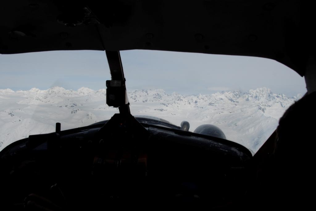
The View from the Cockpit of the Beaver (click on photos to enlarge)

Beaver on Approach


Avalanche Caused by Ice-Fall


Another 1st Ascent and Descent


This was Skied for the 1st Time as Well
Youtube video of the descent (last 2 minutes)