Thursday, June 9, 2011

Pioneer's Part 2

Just wanted to add a little bit more detail about our trip. Let you know what to expect and look for.

Check out the Sun Valley Trekking website and get some info on their Yurt systems.
http://www.svtrek.com/
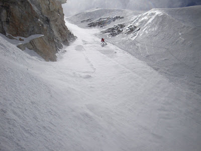
This shot is from Duncans Ridge. The big peak in the back is the Devils Bedstead.

The Pioneer Mountains is a mountain range in the U.S. state of Idaho, spanning Blaine, Butte and Custer counties.

The ten highest peaks of the range are:
Hyndman Peak 12,009 ft (3,660 m)
Goat Mountain 11,913 ft (3,631 m)
Peak 11887 11,887 ft (3,623 m)
Standhope Peak 11,878 ft (3,620 m)
Devils Bedstead East 11,865 ft (3,616 m)
Brocky Peak 11,839 ft (3,609 m)
Altair Peak 11,825 ft (3,604 m)
Old Hyndman Peak 11,775 ft (3,589 m)
Duncans Peak 11,755 ft (3,583 m)
Pegasus Peak 11,736 ft (3,577 m)

The range is bounded on the west by the Big Wood River, Trail Creek, Summit Creek, and the North Fork Big Lost River, on the north and east by the East Fork Big Lost River, Left Fork Cherry Creek, Cherry Creek, Dry Fork Creek, Saint Louis Canyon, and Champagne Creek, and on the south by the Snake River Plain.


Pioneer Yurt has opportunities for those seeking a touring experience, or when conditions permit, to ski the steep and deep. The mountains surrounding the Pioneer Yurt are ideal for ski mountaineering. Big verticle relief on shapely alpine peaks up to 12,000’ with stunning ascent and descent lines. A ski mountaineer’s nirvana!

The Pioneer Yurt is a 24 ’ diameter yurt that sleeps up to 16 people and has all the comforts you have come to expect from a cozy SVT backcountry hut: full kitchen, bunks with pads, wood and propane stoves, lanterns, library, and a great wood fired Sauna!
We approach Pioneer Yurt via Hyndman Creek off the East Fork of the Big Wood River. The ski into the yurt is roughly 6 miles and gains about 2000’ in elevation. The trip can be done in four to six hours by an average group of skiers. The area around the yurt is closed to snowmobiles before March 15th. Up until March 15, snowmobiles may be used to approach the first 5 miles to the yurt and after March 15th, may be used to get right to the yurt.

If you come in the spring expect water crossings and wet heavy snow in the low elevations on your trek up to the Yurt.


As you can see we didn't have much snow to work with on the first half of the trail.


The crew working their way up the west ridge of Cobb mountain.


We called this peak No Name because on the maps we had it didn't have a name.

It's on the check list for the next trip into the Pioneer's.

Mckenna getting the first track down the Comma Couloir down Cobb.
Axel carving his name in Cobb mountain.
Back on the deck of the Pio Yurt just chilling.


I think this was one moring when we had pancakes. We had cake coma and had to take naps before going out to tour.


Realy nice and open space for our crew of seven.

Steph skiing back to the Yurt after a little jump session.


Hyndman Peak, the highest in the range at 12009 feet, was on the list.

Our group spread out and put tracks down all of the four major shots.

This is a great place to come ski. Check it out if you get a chance.

Peace Crossman

Tuesday, June 7, 2011

Jewell Mountain, June 6, 2011

Jewell Glacier (Girdwood area) condition update:

The skiing is great! The road and trail head are free from snow. I was able to walk to the cabin ruins at the old terminal moraine of the Jewell in hiking shoes. The snow is continuous above this point and looked as if it would link with the Raven. There is 3" of new snow (from Saturday night) above 3,800'. The new snow is slush-puppy quality, but it is white and fast. Last night the temperature dropped to 30°F at 3,500'. This AM (June 7) I skied down to 2,300' with minimal portaging using a network of gullies and questionable decision making.


Ragged Top on the Left


Upper Jewell Mountain

The "50 Hikes in Alaska's Chugach State Park" book has detailed information regarding Jewell Mountain (Hike 46).

- U.K.

Sunday, June 5, 2011

Falls Creek: June 5, 2011

I never tour with an ipod, but there is constantly music running through my head. What song would best fit this moment? This sunburst, this send, this booter, this reflection, this sunrise, this wind storm, pealing skins, face shots, ice, powder, crud, slush, wind, rain, whiteout, serene, aggressive, peaceful. Music everywhere. It punctuates and compliments what lays before me. It can be in the background or it can dominate my experience. It may get awfully quiet, but it is always there if I listen for it.

The Noodler tipped me off to a couloir up Falls Creek. His directions were probably excellent, but I wasn't really paying attention. But as fate would have it, I ended up in the recommended shot. It really doesn't come as a surprise, after 12 seasons of touring together he knows my tastes: steep and narrow with a good runout. And when I rounded the bend and looked up into the cirque, I knew this must be the place.

On the Left (Home? Really?)

It looked intrasante. Muy intrasante. Steep. Check. Narrow. Yeah, but maybe too narrow? Good runout. Check. She earned a closer look. No sense turning around without getting all the facts.


She'd be too narrow to slide-slip, but not overly steep. It was on the shady end of my comfort zone. Regret was not an option. The lower angle approach had completed the transition to summer snow: shallow sun-cups with soft crests. The steeps were a bit softer and I expected that aggressive turns would begin a chain reaction which would conclude with the top 3" of the entire chute being relocated to the runout. Like The Jeffesons, but in reverse.

From the Top

It was time to focus. Get psyched. The crux was about 3' wide and was 150' vertical above the runout. The entire couloir never got wider than 10' and the top layer would be nipping at my heals. I knew what had to be done. With playlist on very temporary pause, the skis accelerated into the fall-line.

The Devil Wants to Eat You

Ski like Satan's after you, boy! Every muscle was working in concert; the walls blurred. The next turn was in sharp focus. "You got this!" The crux was bearing down on me and was in my lap and then over my shoulder and then the runout followed by a very specific crush of music and release of endorphins and adrenaline followed directly by Whitman's barbaric yawp!

And from across the valley, a kindred spirit reciprocated with an enthusiastic yawp of her own.

- U.K.

Thursday, June 2, 2011

June 2: McVeigh Creek

McVeigh Creek is a tiny drainage between Arctic Valley and Hiland Road. The Nike site and Gordon Lyon form the upper ridge line of McVeigh.

From the Arctic Valley trailhead, it is a short walk to the former nuclear weapons cache. There are several North Face gullies in this area. From the NW corner of the barbed wire enclosure, I dropped into "Nike #1". The snow was decent for this time of year, albeit a bit slow. My tracks from Tuesday helped with the flat light conditions.

Nike #1

From the bottom I traversed hikers' right to the mid-section of "Nike #2." The booter got progressively steeper eventually maxing out at 52°. The top was thin but quickly transformed into a 400' quarter pipe. Air in. Air out. Repeat.

Nike #2

I worked the run hard. The shores of the tundra closed in. Noodle city, but I refused to surrender. Recently exposed obstacles were becoming more common: willows, rocks, narrow water cuts, 55 gallon drums. The game was getting less and less safe but more and more fun. The snow did end, but I still had some heat, and was able to tundra surf the Big Daddy's about 25' before throwing them on my back.

Clear Skies for the Hike Out
(no artsy black and white necessary)

I tried out the tele-tubby set-up for the first time this year. The results were less than desirable. If you have a strong stomach, give it a shot: Nike #2 (skip to 1:15 for the tundra obstacle course skiing)

- U.K.

2010-2011 Snowfall in Cascadia

2010-2011 has been deep, real deep. Big snow from Mammoth up to Canada and pushing into Utah. There is an interesting thread on TAY with a bunch of snowfall totals and records as of June 1. Most interesting though is the fact the snow isn't melting! No surprise to anyone in the Pacific SE. Check it:
DEEPSNOW

Wednesday, June 1, 2011

Valdez Summit to Sound Challenge: May 29

Saturday: beautiful. Sunday: socked in. Monday: Bluebird. So obviously race day was Sunday. This is the first year of the Summit to Sound Challenge. There are 4 legs:
  1. Rando race at Thompson Pass (Little Odyssey) or nordic race at the pass
  2. Road bike 28 miles from the pass to the ocean
  3. Kayak 3 miles across Valdez Narrows into town
  4. 5K run through town
At race time the fog was thick at the pass. After a one hour delay, the rando portion was cancelled. It would be a triathlon for the teams (or individuals) that had registered in this division. The nordic portion would still take place. This was bull shit; I had come to race and I was going to race. It was billed as an adventure race, and what better way to have an adventure, then to engage in an activity without the proper training or equipment. Four stubborn / dim alpinists defected into the nordic division. Again my Valdez alpine dreams were transformed into a nordic junk show.

Not Ideal Equipment for a 3K Skate

Nordic skiers were released in groups of four and I quickly saw the folly in my critical thinking path, but I finished strong. The Team Head Mistress / flair coordinator was up. Celina hopped on a borrowed bike and disappeared into the fog. The course descends 2,500' feet in about 18 miles. The next 10 are flat. The Head Mistress had a few tricks in her back pocket. She had made friends on the course and formed a team of 3 to improve efficiency.
Wet Roads and Flat Light

The hand off at the put-in went flawlessly. Dean hopped into his borrowed equipment and set off into a cold grey Pacific.


Dean arrived on the Coast Guard beach and John was ready to go. He was our best hope, but he admitted his running shoes came from Wal-Mart. Despite this fact, he made excellent time, advancing the team several positions.

It was now time for the portion of the race our team was best equipped for: salmon fillets and beer. Our grit and skill really shown through and other teams were clearly intimidated. Despite our aggressive nature, new friends were everywhere. The hospitality of Valdez was evident.
A Sharp Looking Team

New friend, Kitty, put us up for the weekend stumbling distance from the finish line. The warm dry house was secondary to the trampoline in the back yard. The next day she brought us out to the local crag out by the airport where she promptly led a 5.9+ sport route.

"Look at me! I'm on the top rope!"

Even though this was the 1st Summit to Sea, it went off without a hitch. It is a testament to the hard work of the race organizers and volunteers. Our team finished 4th out of 9 in the Nordic division; pretty good considering 3 of us did not own the proper equipment for our chosen disciplines.

Check APRN for an alternative account.

-Drew Peacock

Tuesday, May 24, 2011

Pioneer Mountain Yurt Trip Part 1

Once and a while you have to learn the hard way.


This is the start of a five day yurt trip to Idaho's Pioneer Mountains.


You Might think sleds make skiing easier.


Could have just walk right over that tree and had running shoes on for the mile of dirt and rocks that made the sleds run a little hot.


But once you get up to the peaks the mountains make all your trouble's go away.


This is looking down that north chute. On the right in thed picture above.


We where on are way to the Comma chute on Cobb mountain so we passed up that north chute.


This is a little freerider zone we found we could lap with the sleds.


All of the sleds on this trip had a roll or two. Some hit trees and some hit rocks.


Lunch!


This is the north chute of Cobb. We had our sights set on this so even with the firm conditions some of us still wanted to ski it.


A good family meal after a long day.


Just a quick update will add more info and picks soon.


Peace Crossman.


Check out the trailing arms on this sled. Hurricane ties a hammer an a nail to get there lag bolts into the aluminium to brace where they both broke.

Monday, May 23, 2011

Real Time Expedition Tracking Test; Owyhee River

A few of us are heading up to Oregon today to run the Lower Owyhee River. This will be a 5 day river trip in the Eastern Oregon Desert. With this being an interesting and remote river trip, it seems like a good opportunity to test out our SPOT Beacon shared page for tracking future ski expeditions. Satellite location updates should be posted the the following page between Monday evening 5/23/11 and Friday 5/27/11. http://share.findmespot.com/shared/faces/viewspots.jsp?glId=0Jf9PzZyTpSzVJZFtqEZfD4YOhg8bhaAT
Adam M. Lawton

Saturday, May 21, 2011

The End of Winter

I know, I know most of y'all still have gobs of snow. You make sure to let me know this 6 times a day. I get it.

I have officially accepted winter is over as of today. Sub-par (shitty) conditions and a 2-mile stroll to the snow persuaded me. The approaches are longer, the overnight lows are higher, the objectives are peppered with rockfall, the trees are budding, and it isn't getting dark. This by no means the end of the ski season, just a different mindset. Time to tune the bike, hike a ridge, sit on a deck, expose my war-werried shins to the light.

It was an amazing year. I am so fortunate to be able to share so many adventures with so many awesome people. So here are some of my favorite photos from the last 8 months that remind me how much beauty exists in the mountains.

I encourage all the Boyz to go through photos and put up some of your hidden gems.

- Andrzej

Alpenglow on the Equator
October

Cornwallis Storming Suicide Chute
January

Kid Buffalo in Silver Fork
January

The Wind Sculpted Slopes of Turnagain Pass
February

Portage Glacier and Portage Lake
March

Cordova Glacier
April

Saturday, May 14, 2011

Korohusk Couloirs: May 14

I had an objective in mind but no one to ski with. Finally the Noodler relented. Yes!! 2 hours later he called back and expressed his concern regarding the glacier travel necessary for this objective. I told him to close his eyes and repeat 3 times: "Nothing's gonna happen." Apparently this glacial travel technique is not acceptable to new parents.

I spouted off my other objectives and The Noodler's interest was piqued with "Korohusk." There is a scary chute of the North side that I wanted. The Noodler told me that there was also a second, sneekier, scarier couloir as well. He also had some good beta from buddies that had schussed 'em earlier in this season

There was a solid refreeze at the trailhead when we began hiking at 7:15 AM and the skins were on by 8. Travel was efficient on the refrozen corn and soon The Noodler was pointing at an improbable sliver of snow coming off the ridge. As we rounded the bend, it looked doable, but not really.

Korohusk the 1st

I've never seen anything like this couloir. It splits a buttress and has no slopes above or beside it that will slough into the shot. It is relentlessly steep and narrow and there is almost no apron. The Noodler set the booter / clamp-on-er. The snow was "recycled pow", 8" of blower, wintery goodness. We knew it would be good. Each turn sloughed and quickly the surface of 10' wide chute was moving with the skier. Every so often, I'd pull over and let it go on by before it became a hazard.

The Noodler from the Top

After a 5 minute break at the bottom, we moved towards Korohusk the 2nd. This is the shot I had been thinking of: much wider, not as much vert. This line wanted to be my friend, but this too was a trap.

The Noodler and the 2nd

The chute started as advertised, but it doglegged about 700' off the deck. Cramp-ons came out again. It narrowed and got steep. What looked like a relaxing run from below was feeling very similar to the 1st run.

From the Top of the 2nd


"#34, The Noodler, Nashoba Valley, dropping..."

The snow was great, but not as good as the 1st. I navigated the narrows and steeps above the dogleg conservatively, but was able to link turns through most of the top 1/2. The bottom half relaxed a bit, and I felt better. My whipping jacket drowned all other sounds.

A Scary View of the 1st

In AK, you have to be flexible. Years can pass before conditions, weather, and the right partner align to even attempt a line. Today everything converged and the result was easily the best day of the season. That is, until tomorrow.

- Coemul

Monday, May 9, 2011

3 Ranges, 3 Days: May 6-8, 2011

Kenai:
I busted out of my cube at 3:30 and headed straight for Turnagain. Typically the West side of the pass is snow-machine central, but the last day for motorized access was April 30th. Objectives on "Sunny Side" had become much more appealing since silence returned to dominate the soundscape.


Sunny Side Parking Area

Big Chief has haunted me for years and I thought today could finally be the day. I started up a SE aspect at 5:00 PM. There had been some wet slide activity earlier in the day, but the sun was off the route and a stiff wind would provide some evaporative cooling. My route crossed a couple of creeks and ascended a steep gully with consolidated slide debris.

Despite my bullet-proof theories regarding snow safety, slow moving wet slides were laboring down the gully on the regular. Spooky. I traversed out of the gully onto a dry ridge and continued up. The dry ridge eventually ended. A short 50' traverse would get me to another dry sub-ridge but it would be through waste deep slush across a 40° slope. The right decision was obvious but it held no appeal. Shit!

From the tundra, I leaned over and with one hand pushed the top foot of snow down the hill to see what would happen. It started slow, but it got a good head a steam on a roll-over. It was fanning out creating a larger and larger slice of pie. And then it stepped to the ground. Other large pieces pulled out joining the party. The river of snow was now a couple 100 yards wide and wiping out small trees. It ran the full length of the slide path and the sound of moving slush continued for about 10 minutes. I decided beer was now more important than glory. Conservative skiing and driving segued nicely into aggressive drinking.

Talkeetna:
Touring with a large fun group seemed like a better idea for Saturday. I theorized that high, north-facing aspects would provide the best snow, but having completely botched my snow prediction the day before, I kept my mouth shut. As fate would have it, the group decided to ski April Bowl: high and North facing.

The sun was in and out all morning and clouds began to thicken. From the summit, sucker holes gave us hope for a well lit descent. A cold wind was trying our patience and Dean dropped in under flat light. Kelley, then Heather, then Selene, and then the sun made an brief appearance. Bill and I lucked into some great visibility. The snow was fantastic: 6" of wintery, creamy sender! A second lap was a no brainer, and another sucker hole illuminated the descent. Tonight's aggressive drinking would be the inspired by great snow and great people.

The Team


April Bowl

Chugach:
Sunday dawned sunny, but the urge to hibernate in a deep dark cave surrounded by gatorade, soft music, and pizza was powerful. But, I knew Hiland would be great so I worked myself into a frenzy with a series of air punches and self-affirming thoughts. The South Fork Trail is about 50% melted out and didn't really lend itself to either hiking or skiing. After 1.5 miles, I angled West towards the "2nd Notch." From the summit just South of the notch, I "sent the shit" out of a mellow face towards Ship Creek. Excellent corn made for effortless skiing. Run 2 began from the same summit, but this time the NW face called. Again, smooth corn in the sun is tough to beat. I wanted a third, but dehydration was dominating my skull. The only wise option at this point was to locate the mythical electrolyte cave.

- James Dalton