Thursday, June 7, 2012

The X Couloir: June 4, 2012

Looking at the weather forecast on Sunday, it appeared that Tuesday would have the best weather.  I had a few ideas of what to attempt, but half-heartedly decided on the X-Couloir. 

A cloudy Tuesday morning transitioned into a brilliant afternoon. Today would be my best opportunity to go for this bigger objective. I blew out of work at 2:30, biked home, and loaded up the Taco, and was hiking by 3:30. 

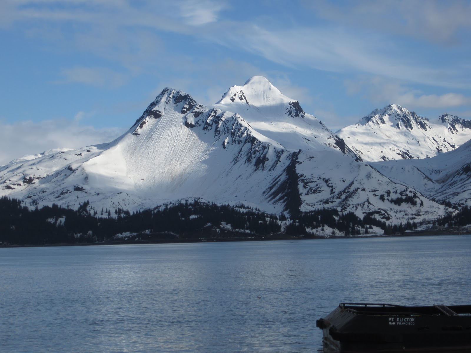
The X Couloir is on the North side of Mountain Peeking which is about 10 miles up Peter's Creek. Typically this is accessed via the Ram Valley trail and then taking a left on the Falling Waters trail.  Legal access to Ram Valley definitely falls into a grey area because of private property issues.  It definitely helps if you know someone who has land adjacent to the CSP. 

The start of the hike was super nice amongst the Alaskan Lupine and budding trees. The trail was dry and  snow-free high into the Falling Waters drainage.  At about 3,500', I swapped out the approach shoes for boots and started skinning.  Falling Water is a serpentine drainage that zigs and zags. 


Route Up the Winding Drainage
Finally I was in the high cirque with Mountian Raina on my right. and Mountain Peeking straight ahead.    

Raina from the Top of the X
Going against generations of conventional Mormon wisdom, I opted to "Choose the Left."  The ridge off the summit of Peeking (East to West) makes a distinctive "W" shape against the horizon.  The low points of the "W" mark the entrance points to the top couloirs of the "X."  The left couloir starts lower and is wider, so again I chose the left.

From the col (6,100'), I got my first look at my descent route.  It is wide, but long and steep (~ 40°, 2,200').  The shot is 100% North facing and was still completely in the shade at 7:30 PM.  At some point in the prior week, the snow in the couloir got well above freezing and then froze solid.  Dropping in, the snow was bullet-pack.  If the surface was smooth, only my edges would be preventing a slide for life. Fortunately, someone had skied the shot when it was manky which roughed up the surface considerably.  Jump turns down, down, down, aiming for the trenches and high spots left frozen in place by an unknown benefactor.  The angle refused to ease.  At the nexus, I had a choice of which leg to descend.  The narrow left was about 10' wide, but the snow was still very firm.  This time I decided to "Choose the Right."  In the lower half, the snow began to soften, but it was a mix of runnels and avalanche debris.  I aimed for the smoother sections and got some decent turns as the angle finally began to ease.


The X: Skied Top Right to Bottom Left
(Note "W" shape on the ridgeline)
It was 8 PM and now I was the Peter's Creek drainage.  The options were boot back up, or work my way back to Falling Waters with 2 short 1,000' climbs on South facing tundra.  The tundra seemed inviting, so I loaded up my gear and started walking. 

At the top of the 1st 1,000' climb, I sussed out my descent into the next basin.  I had expected to ski this section, but it was 90% melted out.  It wasn't ideal, but it didn't look too bad.  I planned to down-climb to a narrow band of snow and then sideslip all the way to the floor of the next cirque.  See #1 in the photo below. 


At Point 1, the snow looked super sketchy.  I was hoping for consolidated neve, but what I got was fully saturated slush somehow clinging in place.  This was beginning to look like a bad idea.  I took my skis off my pack and hacked at the snow pack with my tips.  This released the slush / snow to the ground and it accelerated down the slope moving with the consistency and the roar of rushing water.  As the slide ripped down the gully it was gathering debris and more snow.  The snow only ripped out only as far as I was able to slash with my tip (about 10% of the snow width).  What did rip, ripped to a frozen wet tundra bed surface. 

The downclimb had already been steep, but with the promise of 4 edges I was confident getting down to Point 1.  Now that skiing was out of the question, the down climb became much more serious.  My skis were already off the pack.  I decided that the increased freedom of movement was more valuable than my 3-year old spring rock skis. So I hucked them down slope in the hope that they would find their way to the valley floor.  They stopped at Point 2.  Buh-bye. 

I followed the Red Line (line added with iPhoto - not actually present in real life) down to the next snow patch.  At this point I realized I was above a massive cliff.  Fuck!  But I was able to spy a goat path traversing above the cliff band.  Goats are typically smarter than me, so I put my trust in these intellectual superiors and aimed for their route. 

Crossing the wet frozen slide gully at Point 3 was nerve-wracking especially since I was now aware of the large cliff below.  There was only 1 crucial step so I got some momentum to carry me across in the event of a slip.  The foot held and I was across. I worked my way down to the goat path at Point 4.  This was no guarantee that this path would lead anywhere, but it was my best option. 

Goats have massive balls; balls that clank, that's for sure.  This 6" wide path skirted less than 6" from the edge of the cliff.  The path would be easy if it were in a nice grassy meadow, but exposure has a way with fucking with you.  I moved with purpose and tried to block out the void that the ski pole in my right hand was suspended over.  And after the longest 20 seconds in recent memory, I was on an island of safety. 

The route to the valley floor was now obvious and after a quick glisade I had made it.  Thank God!  Thank you Adam, Sroga, Roberta, Memere, Jane, and all of my other guardian angels. There was still another 1,000' of climbing, but could see the entire route and had already sussed out the descent into Falling Waters.  The worst was now behind me.

My Route: Far Right
Preferred Route: Far Left
The next climb would be an easy skin.  That is had I not abandoned my skis. It would be a booter, a deep booter, a miserable booter, up to my crotch and many places.  I tried to link as many tundra patches as possible.  It was exhausting but there was progress.  The pass finally yielded and descent was exactly as I remembered: consolidated snow with perfect scree.  I was down in a matter of minutes.

Expert Route Finders Enjoying the Sunset: 10:30 PM
I followed my skinner back to my transition station and threw my ski boots in the pack. Without skis on my back the hike out was super nice.  It was a glorious Alaskan night. The high peaks were ablaze in the fading light. Due to the high latitude, the Alaskan summer sun moves almost parallel to the horizon this time of night.  This makes for a magic hour that actually lasts for an hour before the suns dips slightly out of sight for a few hours of dusk/dawn.

Polar Bear Peak: 11:00 PM

Sleeping Lady and the Knik Arm: 11:30 PM
It took 8 hours. The snow was poor. I lost gear. I scared the shit out of myself. I was completely exhausted. I questioned my decision making skills, my sanity, my intelligence, but I had made it. I wouldn't want to put myself in that type of situation again, but I was happy. 

 - U.K.

Monday, June 4, 2012

Summit 2 Sound: Valdez

The second annual Summit 2 Sound went down in Valdez, AK on Memorial Day Eve Day.  Last year, due to a timing error, we were awarded last place. In Alaska this is known as the Red Lantern.  So we were back determined to regain / defend our honor.  

Expresso / Soup / Ice Cream Truck
3/4 of our team returned from last year.  Team "Valdez Nuts" had high hopes. As with last year, the weather was shit at the pass. The first leg involved a quick skinner up Mountain Little Odyssey right at Thompson Pass. Groups of 4 were sent every 5 minutes. Gear varied: split boards, snow-shoes, AT, new, old, light, heavy.

Snowing on Thompson Pass
It was snowing hard at the Pass which was no big deal for the skier, but the snow was mounting in the transition area.  The road biker would be in for a miserable ride. Snow and slush eventually gave way to a cold rain and road construction.

Through the Canyon
The stubborn rain continued, but Celene hammered on making good time and 26 miles later she was at the kayak beach.  The transition was awkward at best and left Celene sprawled out on the ground. Fortunately she was fine and Dean made his way to the water.

Starting the Kayaking Leg
The kayak leg starts on the far side of the Valdez Arm and heads towards town.  Skies were grey, but seas were flat making for good conditions.  Laura was pumped for the 4.5 mile through town and beat her pre-race estimate.
Ringing the Bell at the Finish
We were done and there still were teams left on the course, but this does not guarantee a red-latern free race because there are 4 divisions and each has its own last place award.

Like last year, skies cleared up after the race making for a beautiful afternoon.  The award ceremony wasn't until 6 PM so we had a few hours to kill.  So over to the Fat Mermaid to crush a few pitchers of Ghost Town Brown.  The award party was at Kelsey Dock known locally as "The Pringle" due to a pringle shaped canopy that covers the stage and some picnic tables.

From Valdez looking across the Port
We knew we didn't win, but we were nervous about the Red Lantern, and we breathed a sigh of relief when our name was not called.  Now we could get down to some partying!

The next day was Memorial Day and to celebrate our impressive finish, the entire team including our professional cheer leader, Emily, went out for a day of sea kayaking with Pangaea. We rode the water taxi for 2 hours to a terminal moraine about ten miles from where the Columbia Glacier calves into the sea.

The moraine traps all the ice in this 10 mile section of the fjord. Water drains in and out through several shallow channels with the changing tides, but the ice stays trapped.

On the Moraine
You easily paddle through the shallow channels to enter into the icy labyrinth. The sound of ice cracking and splashing into the water is constant. Glacial ice bergs are blue-est below water line, but because of the low tide, many larger chucks were grounded in the shallows exposing the blue ice to the daylight.


After 4 hours of paddling, it was time to get back on the boat.  We had good luck with wildlife on the way to the glacier, and our luck continued on the ride back. All told, we saw orcas, humpbacks, otters, porpoise, sea lions, and many birds that nobody cared about.

We were worked, but I needed to be back at work first thing Tuesday morning, so Laura and I hit the road.  The wildlife parade continued on the drive back: eagles, caribou, Dall sheep, a brown bear, porcupines, and moose aplenty.

Mother and Child
Work sucked. All I could think about was napping and as quitting time approached visions of my bed were dominating my semi-conscious thoughts.  The time had come, but just before flipping the switch, I checked my email. The Official Race were in and there had been a mistake on race day. Due to a timing error on race day the Red Lantern was improperly awarded to the wrong team.  It was ours.

Again.  

I'm already thinking 3-peat.

 -U.K.

Friday, May 25, 2012

Dr. Shred Gnar

Skier Boyz original gang-star A. B-Gnar is riding across the USA to raise money for FACE AIDS.

Follow her as she documents her journey:

Good luck Doc Gnar!!

Thursday, May 24, 2012

Falls Lake Couloir: May 23, 2012

Falls Creek is couloir central.  There are about 10 puckering shots in the 500' - 1,200' range in this small drainage.  Most top out between 3,500' and 4,500'.  The only drawback is that you start from sea level. Back in April, the Noodler and I climbed South Suicide via Falls Creek and I saw a shot that I needed to ski.  Of course the Noodler had skied it several times.  We didn't have time that day, but I planned to return.

Falls Lake Couloir (FLC): April 20
The FLC has all the earmarks of a classic: narrow, north facing, close to the summit, and an excellent run out.  The only thing that isn't obvious is the location of the lake.  Don't know, don't care.

I returned to Falls Creek the afternoon of May 11.  The Noodler and MB were already up there on an all day couloir hunt and I was fortunate to catch them at the bottom of the FLC.  Unfortunately there was 2-3 feet of freshly wind loaded snow in the couloir. The Noodler and MB had already turned around on another shot earlier in the day due to cracking snow. It had taken 2 hours to get to the bottom of the FLC, but the risk was not worth it. 

Turning Around
Anchorage has had a seemingly never-ending corn cycle since mid-March. Sunny days with cool clear nights has made for excellent skiing.  Hard frosts in town guaranteed excellent late afternoon skiing in the mountains.  This came to an abrupt end this week.  The clouds rolled in preventing temps from reaching the freezing level overnight.  It happens every year, but it was much later than normal in 2012.  Once it happens, the snow goes to shit rapidly before slowly transforming to neve a few weeks later. 

During this transition, a wise skier would stick to the trade routes that see the most traffic (Peak 3) or seek out some gullies that have been wind blasted all winter (Solstice Couloir).  Harp on Monday was a manky mess.  My skis were fat enough to keep me on top, but just barely.  Pole plants easily punched through 12+ inches into the isothermal slush.  Spooky.

Wednesday dawned warm and cloudy but sun was in the forecast.  I always try to work an extra hour on crappy days, so on beautiful days I can sneak out early.  The sun came out and I made a break for it and was hiking by 3:30 PM.

The Falls Creek trail is dry and first mile does not hint at the massive snow pack higher up. 
  
Fiddle Heads Provide a Nice Snack
After about leisurely 2-hour hikes, it is time to take the skis off the pack and start skinning. I retrace my May 11 route but was I am moving much slower today.  The skins are completely saturated adding significant weight to my already heavy set-up.  Ski penetration is 2-3" and the top 4" are completely saturated.  I slog along slow and steady with the hope that the FLC will be much firmer being higher up and in the shade. But this is unlikely with air temp in the 50s. 

At the May 11 turn-around point the snow is slightly better.  The feet of snow from a few weeks prior is still in there but it has cooked down considerably and has insulated the frozen layer beneath.  With skis back on the pack, the booting begins.  Each step is about 8" deep.  The snow in the chute hasn't gone to corn yet; it is really saturated spring snow: the ultimate snow ball snow.  The sun is blasting the wall above the climber's left and there is evidence of fresh rock-fall.  I keep to the right and waste little time and before too long the ridge yields.

Near the Summit of Mountain Peak 3920
The vista is amazing.  Couloirs everywhere and a great view of the lower Falls Creek, the Turnagain Arm, and Hope, AK.  After a short time taking it all in, it is time to focus on the task at hand.  The FLC is in the high 30s and today it is mank-tastic.  The top 8" is on the cusp of sliding.  It wants to go, but not quite.  Ski cuts get small results.  I link 2 turns down the center and ski towards the wall to see what happens.  Manky roller balls.  I repeat this technique about 1/4 of the way down before I feel comfortable enough to start linking more turns.  The snow is slow but super fun and carving pretty deep.  The shadows of the couloir finally give way to the sunshine of the run out and finally I relax.
 
Looking Back Up
It always feels good to get a shot that has captured your attention. FLC has been weighing on me since I saw about a month ago.  One month is not that long considering there are lines that I have obsessed over for years, but it was a good feeling nonetheless.  Hopefully, the transition to neve will be quick so I can tick a few more off before this season winds down.

 - U.K.

Monday, May 14, 2012

1,000" Winter


We made it by my count.  Alyeska is reporting 959" since October 1.  Check out today's snow report.


"Well, 959 seems to be less than 1,000," you may be saying.  
"I may be no math-a-magician, but I think you're off by 41"

The key here is: "Since October 1st." I solemnly swear that there was at least 41" before October 1, and I offer these 2 photos as proof.  These both were taken in the Crow Pass area near Alyeska.


September 23

Early morning October 1
 So, I say: "Count it."

You got your 1,000" winter, Adam.

 -U.K.


Wednesday, May 9, 2012

Mountain Penguin Peak: May 4, 2012

Work had sent me out of town for the second week in a row depriving me of the excellent early May skiing Anchorage has been blessed with.  I knew my flight would be landing around 1:30 PM, so I loaded the truck with the requisite ski gear before going to the airport.  

The flight back took me over the heart of the Chugach: huge peaks, tidewater glaciers, infinity ski runs.  I was amped and ran from the terminal to long term parking and headed South down the Seward Highway.  I wanted mine.  

The Noodler had been keen on Penguin Peak for the last week or so.  Penguin is often overlooked but highly visible from the highway.

Penguin and the Turnagain Arm
Anchorage had a record snow year, so I there has been no need to drive very far to get the schuss.   This has meant mostly skiing the Chugach State Park.  The park is huge extending roughly 40 miles North, South, and East from Anchorage.  There are dozens of trailheads.  Some are official, most are not.  The route up Penguin happens to start at one of the official entrances.


The run climbs a 3,000' slide-path that averages in the low 30s.  Evidence of large slides are everywhere.  The slides originate from the climbers right hand side from a large steep ridge. Fortunately today is a corn mission and the snow is still very firm. Eventually the main run rolls over to reveal a mellow bowl towards the summit.  The approach is super mellow; maybe 3 switchbacks.  


The Upper Bowl
From the head of the drainage, there is 3,900' of excellent continuous skiing with the cold grey Pacific in your lap.  But the head is a false summit of Mountain Penguin Peak.  The schuss will have to wait.

The Summit Ridge from the False Summit
The ridge is straight forward but firm.  I didn't have a self arrest device, so I opted to boot the 200 yards to the top.  After the short detour, it was time to ski.  

4,100' to the Turnagain Arm looking towards Anchor Town
The top hadn't softened, but that was OK.  A recent squall had placed 2" of new on the top half. The frozen corn underneath was super smooth, so this made for some super fun, high speed turning. The recent snow transformed seamlessly into perfect 2" deep corn around 2,500'  The snow lost the bright white appearance around 1,000' and got a bit punchy and considerably slower, but it was continuous to the parking lot.

It's good, I will return.

 - U.K.

P.S.  Hit it again on 5/8 - still skiable to the lot


Monday, May 7, 2012

Leuthold's Col on Mount and Hood

Skier Boyz PNW division checking in. Last night I was crushing beers at Double Barrel Brew Co in Hood River, Oregon and ran into some folks who got me stoked on corn today. I thought I'd have to wait another day for that, but I was wrong. I took the chair lift to the top of the resort, and started hiking at about 10: and a half inch cock. Several spliffs later I found myself floating up the South Side of the Hood Wand, where I encountered some French Folks. They live in La Grave and were soooopah cool. We hung out at the summit, ate some fromage, had a beer (Poured a little out for Adam), had another spliff, and enjoyed the the glorious HIGH pressure. We decided to ski together and they were psyched on my descent plan, Senor Leuthold's Col. After a few hundred feet of rime ice we found our way into the chute. 2,000 ft of corn later we bottomed out and did a 300 ft hike up the the Illumination Cock saddle. We then skied down the Zig Zag and traversed back to the piste which led us to lot. Word is that a few buffalo's will be in the area tomorrow and there might be some more corn harvesting.
~Temperature Gradient

Friday, April 27, 2012

Falls Creek: April 20

The Noodler and I finally linked up for a rare full day tour, that is full day for me (not for him).  We were at the Falls Creek trailhead and skinning by 10:30 AM.  

Starting at Sea Level
 It was warm and sunny and we were worried that we might be too late.  With beer stashed in a nearby snowbank and guarded by Devils Club, we marched up the trail in hiking shoes.  At about 500', it was time to put on the boots and start skinning.  Staying on the trail became difficult: with feet of snow on the ground the route isn't entirely obvious.  It becomes degrees of shwacking and fighting and veggie belays.  Eventually we got into the well filled-in creek bed and travel efficiency greatly improved.

Out of the Scrub
Falls Creek is Couloir City and the stoke was high.  It seemed that we were a bit late for South aspects and early for North.  We opted to to continue higher and see what would unfold.

Not Alone

Options for Next Time
As we climbed higher, more couloirs became obvious, but we were already in the mellower upper portion of the drainage.  We decided to attempt the high point: South Suicide (5,005').  The sun was just barely starting to melt the snow in the upper bowl, but it was taking a brutal toll on the climbers.  There was nowhere to hide.  Temps were in the 40s but the sun, bright white snow, and a complete lack of wind conspired to kick the shit out of me.  

Finally the slope angle eased, a feeble breeze kicked up, and a dry rock provided an opportunity to recuperate.  I finished my water and chocolate and used the corn snow to get the salt out of my eyes and face.  I put it in low and eased my way up to the head of the drainage.  

The Noodler scrambled the last 100' to tag the summit while I rested.  After about 20 minutes we were both ready to reap the reward of our effort.  There was 4,500'+ of continuous snow below us and I was confident the first 3,500 would be awesome.  Below that would get interesting.

Top of Falls Creek

I gave the top 2,000' an A+.  The Noodler only gave it an A, but as you can see, he was much more intimate with the snow than I.  The corn fiesta continued lower and lower.  We knew it had to end eventually, but we were continually surprised with the quality as we descended towards the sea.

Wet Slide Debris
(the s isn't silent)
It was unspoken, but we both were well aware it would have to get very silly before either of us would click out.  Debris, bushes, mud, open water.  Check, check, check, and check.

Good Times
We actually descended to about 600', much lower than we expected.  The Noodler gave me a strange look when I strapped my skis to the pack.  He is of the opinion that carrying your skis in your hand is much faster.  He explained the pros and as if to make a point, he was off in a flash. I wasn't too worried because the keys were in my pocket.

Shit, he knows where the beer is!

I tightened my straps and was off in an awkward hustle into the mud and bushes with the rapidly fading hope of beer below.

 - U.K.

Thursday, April 26, 2012

Mid April Upate: Alaska

Blue skies, warm days, and cool nights have made for some A+ corn skiing in South Central AK.

The Alaska Range

April has been focused on "The Iggle." I've been able to get out most days after work just as the South facing slopes begin to soften.  Unfortunately, this week I am in Kuparuk, Alaska for work. Temps here are in the teens and there is 3-6" of new low density powder on top of a supportable base, but the nearest hills are over 100 miles to the South. Shoot!

Some recent Iggle ski trails that we schussed in the last week or so....

I hope everyone is having a great spring!

 - U.K.


Lynx

Swiss Bowl and East Swiss

North Face of Gordon Lyon
(not sure I'd sleep well in either home at the bottom during a big storm cycle)


Saturday, April 21, 2012

Seward Highway Couloir: April 19

Such a beautiful shot: 3,500' of sustained bliss. Whether corn, or powder, or frozen basketballs, this line always delivers.

Anchorage's record winter has transformed into an aggressive spring. In early March, we were just a few inches shy of the all time record in town. In took over a month to limp to the finish; we did not finish strong. March and early April are typically the work horse of the base building season, but not this year. Down, down, down, but there is still plenty of snow.

Taken April 2011

Wednesday morning left a frost on the vehicle, so I knew I'd be skipping out of work a bit early to take a quick shot at her before the sun scorched it. I hustled to the trailhead and started up. As expected, the recent warm weather had left debris aplenty in the lower portion, but the midday heat has soften the chucks considerably and furry woodland critters were beginning to melt out.

Sheep or Goat?


The First 1,800'

The bottom half is straight forward. You can even skin to about 1,200', but then it is booter city. The second half is fun too, but the link between the two is definitely the toughest part. Just before the crux, my non-ironic flip-phone starting playing Axel F: it was the Noodler. He recognized my vehicle and gave me a call. He was hot on my tail with a couple of buddies.

I relayed the 4:45 snow report, closed my phone, and booted up and around the corner. The crux is in the mid 40s and our relentless Spring has taken its toll. Today, it was plenty wide (6') but only 1-2' deep and rotten to the rock.

Above the Crux

Above the snow was getting pretty mushy. The sun had beaten me. "Push-alanche" skiing would be likely. If I topped-out Noodler & Co. could be exposed to anything I kicked off. I felt this was unlikely, but it wasn't worth the risk.

I flipped my phone to "open" and used the number keys to get to the N's.

"Dropping."

Being solo and above the crux was giving me distress. I cut the slope and it wanted to go, but didn't. Not real helpful; it was right on the verge. I got a good side-slip going to try and clear out the mank, and this worked pretty well. It was slow going to the crux, but after a quick straight line, I was through.

The bottom was great: carvy snow and slip-able debris. I saw the team lower and schussed up to them and recited the 5:30 snow report.

Not too long ago, missing out on the top 1,500' would have bothered me, but this a been a winter of shifting perspectives. Today I was more than content: 2,000' to the ocean in the sun with excellent snow is a great silver medal. Ah yes, new found perspective and knowing that it was much better when we hit in February.

- U.K.

Monday, April 9, 2012

Harp: April 9

Anchorage finally got the 3" necessary to make it the snowiest winter ever. It was merely ceremonial here in town. No one shoveled and the plows stayed in, but there was enough to make the skiing above town fantastic.


Or so I heard. I spent the weekend gladly helping friends with various projects, but Monday afternoon I had to do what was right for me, because it was their time, their time, up there.

To my surprise, the west face of Harp was skiing great: 6-8" of blower on supportable. And once you got up to speed, it was a smooth ride. Can't wait to get out tomorrow!

- U.K.

Wednesday, March 21, 2012

Congrats Green Mountain Freeride!

I went up to Snowbird on St. Patty's Day to cheer on the GMFR team, and they did not disappoint!


Dylan on Day 1


Sussing out North Baldy on Day 2


The Grandstand: Day 2

Check out Silas's winning run: click here
And Dylan's: click here

- U.K.